You are here: Home > Network List > GO - National Seismic Network of Georgia Stations List
> Station MINA Georgia, Mina > Earthquake Result Viewer
MINA Georgia, Mina - Earthquake Result Viewer
| Earthquake location: |
Reykjanes Ridge |
| Earthquake latitude/longitude: |
53.9/-35.1 |
| Earthquake time(UTC): |
2022/11/29 (333) 23:50:37 GMT |
| Earthquake Depth: |
10 km |
| Earthquake Magnitude: |
5.5 Mww |
| Earthquake Catalog/Contributor: |
NEIC PDE/us |
|
| Network: |
GO National Seismic Network of Georgia |
| Station: |
MINA Georgia, Mina |
| Lat/Lon: |
41.60 N/43.02 E |
| Elevation: |
1568 m |
|
| Distance: |
51.3 deg |
| Az: |
70.033 deg |
| Baz: |
312.162 deg |
| Ray Param: |
0.06747863 |
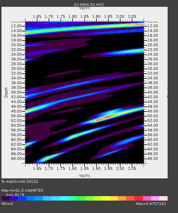
| Estimated Moho Depth: |
51.0 km |
| Estimated Crust Vp/Vs: |
1.92 |
| Assumed Crust Vp: |
6.419 km/s |
| Estimated Crust Vs: |
3.348 km/s |
| Estimated Crust Poisson's Ratio: |
0.31 |
|
| Radial Match: |
80.08152 % |
| Radial Bump: |
400 |
| Transverse Match: |
75.24815 % |
| Transverse Bump: |
400 |
| SOD ConfigId: |
29823551 |
| Insert Time: |
2022-12-14 00:04:38.526 +0000 |
| GWidth: |
2.5 |
| Max Bumps: |
400 |
| Tol: |
0.001 |
|

Signal To Noise
| Channel | StoN | STA | LTA |
| GO:MINA:00:HHZ:20221129T23:59:11.280014Z | 3.0881622 | 3.0580475E-7 | 9.902483E-8 |
| GO:MINA:00:HHN:20221129T23:59:11.280014Z | 0.98433775 | 9.164822E-8 | 9.310647E-8 |
| GO:MINA:00:HHE:20221129T23:59:11.280014Z | 1.7191851 | 1.0556789E-7 | 6.140578E-8 |
| Arrivals |
| Ps | 7.7 SECOND |
| PpPs | 22 SECOND |
| PsPs/PpSs | 30 SECOND |


