You are here: Home > Network List > XA95 - Missouri to Massachusetts Transect Stations List
> Station MM13 Spiceland, Indiana > Earthquake Result Viewer
MM13 Spiceland, Indiana - Earthquake Result Viewer
| Earthquake location: |
Near Coast Of Peru |
| Earthquake latitude/longitude: |
-11.5/-77.6 |
| Earthquake time(UTC): |
1995/06/21 (172) 16:33:05 GMT |
| Earthquake Depth: |
70 km |
| Earthquake Magnitude: |
5.5 MB |
| Earthquake Catalog/Contributor: |
WHDF/NEIC |
|
| Network: |
XA Missouri to Massachusetts Transect |
| Station: |
MM13 Spiceland, Indiana |
| Lat/Lon: |
39.83 N/85.31 W |
| Elevation: |
337 m |
|
| Distance: |
51.6 deg |
| Az: |
352.39 deg |
| Baz: |
170.297 deg |
| Ray Param: |
0.06709044 |
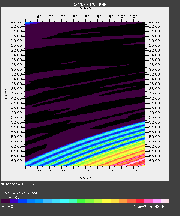
| Estimated Moho Depth: |
67.75 km |
| Estimated Crust Vp/Vs: |
2.07 |
| Assumed Crust Vp: |
6.498 km/s |
| Estimated Crust Vs: |
3.139 km/s |
| Estimated Crust Poisson's Ratio: |
0.35 |
|
| Radial Match: |
91.12668 % |
| Radial Bump: |
138 |
| Transverse Match: |
92.18888 % |
| Transverse Bump: |
104 |
| SOD ConfigId: |
29242 |
| Insert Time: |
2010-02-26 17:53:07.840 +0000 |
| GWidth: |
2.5 |
| Max Bumps: |
400 |
| Tol: |
0.001 |
|
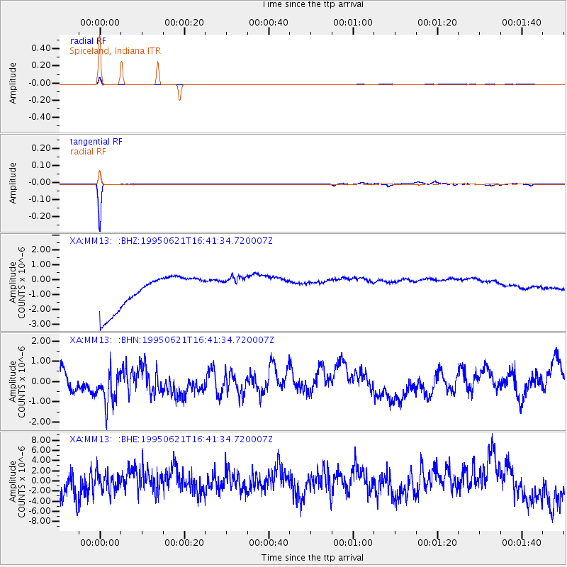
Signal To Noise
| Channel | StoN | STA | LTA |
| XA:MM13: :BHN:19950621T16:41:34.720007Z | 1.7751462 | 9.816597E-7 | 5.5300217E-7 |
| XA:MM13: :BHE:19950621T16:41:34.720007Z | 0.74462384 | 1.7969179E-6 | 2.413189E-6 |
| XA:MM13: :BHZ:19950621T16:41:34.720007Z | 0.77956635 | 8.5693483E-7 | 1.0992455E-6 |
| Arrivals |
| Ps | 12 SECOND |
| PpPs | 30 SECOND |
| PsPs/PpSs | 42 SECOND |


