You are here: Home > Network List > XA95 - Missouri to Massachusetts Transect Stations List
> Station MM13 Spiceland, Indiana > Earthquake Result Viewer
MM13 Spiceland, Indiana - Earthquake Result Viewer
| Earthquake location: |
Kuril Islands |
| Earthquake latitude/longitude: |
44.1/148.1 |
| Earthquake time(UTC): |
1995/04/28 (118) 16:30:00 GMT |
| Earthquake Depth: |
29 km |
| Earthquake Magnitude: |
6.6 MB, 6.9 MS, 7.0 UNKNOWN, 6.8 MW |
| Earthquake Catalog/Contributor: |
WHDF/NEIC |
|
| Network: |
XA Missouri to Massachusetts Transect |
| Station: |
MM13 Spiceland, Indiana |
| Lat/Lon: |
39.83 N/85.31 W |
| Elevation: |
337 m |
|
| Distance: |
83.6 deg |
| Az: |
38.445 deg |
| Baz: |
324.399 deg |
| Ray Param: |
0.046011098 |
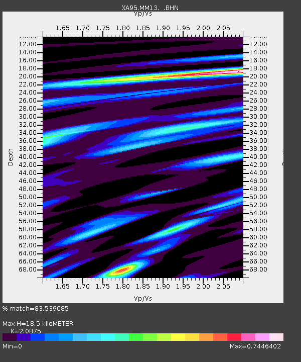
| Estimated Moho Depth: |
18.5 km |
| Estimated Crust Vp/Vs: |
2.09 |
| Assumed Crust Vp: |
6.498 km/s |
| Estimated Crust Vs: |
3.113 km/s |
| Estimated Crust Poisson's Ratio: |
0.35 |
|
| Radial Match: |
83.539085 % |
| Radial Bump: |
400 |
| Transverse Match: |
62.138382 % |
| Transverse Bump: |
400 |
| SOD ConfigId: |
6273 |
| Insert Time: |
2010-02-26 17:53:10.041 +0000 |
| GWidth: |
2.5 |
| Max Bumps: |
400 |
| Tol: |
0.001 |
|

Signal To Noise
| Channel | StoN | STA | LTA |
| XA:MM13: :BHN:19950428T16:41:55.166003Z | 2.4716325 | 1.2092962E-6 | 4.8927023E-7 |
| XA:MM13: :BHE:19950428T16:41:55.166003Z | 1.4638692 | 4.6066864E-7 | 3.146925E-7 |
| XA:MM13: :BHZ:19950428T16:41:55.166003Z | 5.7781916 | 2.7964807E-6 | 4.839716E-7 |
| Arrivals |
| Ps | 3.2 SECOND |
| PpPs | 8.6 SECOND |
| PsPs/PpSs | 12 SECOND |


