You are here: Home > Network List > TA - USArray Transportable Network (new EarthScope stations) Stations List
> Station D30A Buchanan, ND, USA > Earthquake Result Viewer
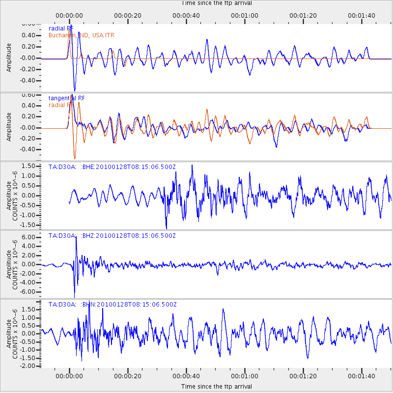
D30A Buchanan, ND, USA - Earthquake Result Viewer
*The percent match for this event was below the threshold and hence no stack was calculated.
| Earthquake location: |
Jujuy Province, Argentina |
| Earthquake latitude/longitude: |
-23.4/-66.7 |
| Earthquake time(UTC): |
2010/01/28 (028) 08:04:14 GMT |
| Earthquake Depth: |
208 km |
| Earthquake Magnitude: |
5.8 MB, 5.9 MW, 5.9 MW |
| Earthquake Catalog/Contributor: |
WHDF/NEIC |
|
| Network: |
TA USArray Transportable Network (new EarthScope stations) |
| Station: |
D30A Buchanan, ND, USA |
| Lat/Lon: |
47.11 N/98.76 W |
| Elevation: |
465 m |
|
| Distance: |
75.9 deg |
| Az: |
338.053 deg |
| Baz: |
149.812 deg |
| Ray Param: |
$rayparam |
*The percent match for this event was below the threshold and hence was not used in the summary stack. |
|
| Radial Match: |
64.03446 % |
| Radial Bump: |
400 |
| Transverse Match: |
69.47405 % |
| Transverse Bump: |
400 |
| SOD ConfigId: |
296938 |
| Insert Time: |
2010-04-07 00:55:15.680 +0000 |
| GWidth: |
2.5 |
| Max Bumps: |
400 |
| Tol: |
0.001 |
|
Signal To Noise
| Channel | StoN | STA | LTA |
| TA:D30A: :BHZ:20100128T08:15:06.500Z | 14.540052 | 2.2073787E-6 | 1.5181367E-7 |
| TA:D30A: :BHN:20100128T08:15:06.500Z | 1.5693814 | 5.0284336E-7 | 3.2040865E-7 |
| TA:D30A: :BHE:20100128T08:15:06.500Z | 1.8881361 | 4.85908E-7 | 2.5734798E-7 |
| Arrivals |
| Ps | |
| PpPs | |
| PsPs/PpSs | |


