You are here: Home > Network List > IU - Global Seismograph Network (GSN - IRIS/USGS) Stations List
> Station XMAS Kiritimati Island, Republic of Kiribati > Earthquake Result Viewer
XMAS Kiritimati Island, Republic of Kiribati - Earthquake Result Viewer
*The percent match for this event was below the threshold and hence no stack was calculated.
| Earthquake location: |
Loyalty Islands |
| Earthquake latitude/longitude: |
-21.3/168.5 |
| Earthquake time(UTC): |
2017/11/19 (323) 22:43:29 GMT |
| Earthquake Depth: |
25 km |
| Earthquake Magnitude: |
7.3 Mi |
| Earthquake Catalog/Contributor: |
NEIC PDE/at |
|
| Network: |
IU Global Seismograph Network (GSN - IRIS/USGS) |
| Station: |
XMAS Kiritimati Island, Republic of Kiribati |
| Lat/Lon: |
2.04 N/157.45 W |
| Elevation: |
20 m |
|
| Distance: |
40.6 deg |
| Az: |
59.316 deg |
| Baz: |
233.366 deg |
| Ray Param: |
$rayparam |
*The percent match for this event was below the threshold and hence was not used in the summary stack. |
|
| Radial Match: |
80.94423 % |
| Radial Bump: |
400 |
| Transverse Match: |
60.036194 % |
| Transverse Bump: |
400 |
| SOD ConfigId: |
2973751 |
| Insert Time: |
2018-10-09 02:46:03.081 +0000 |
| GWidth: |
2.5 |
| Max Bumps: |
400 |
| Tol: |
0.001 |
|
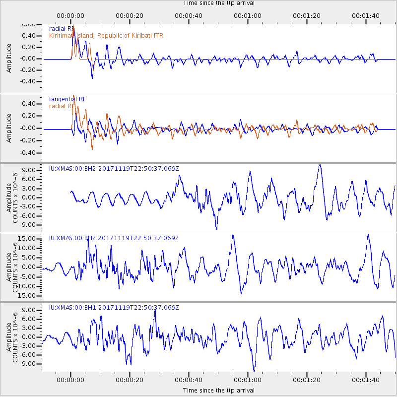
Signal To Noise
| Channel | StoN | STA | LTA |
| IU:XMAS:00:BHZ:20171119T22:50:37.069Z | 1.2189953 | 2.908167E-6 | 2.385708E-6 |
| IU:XMAS:00:BH1:20171119T22:50:37.069Z | 1.5433812 | 1.9202816E-6 | 1.2442043E-6 |
| IU:XMAS:00:BH2:20171119T22:50:37.069Z | 1.1180385 | 1.5846828E-6 | 1.4173775E-6 |
| Arrivals |
| Ps | |
| PpPs | |
| PsPs/PpSs | |


