You are here: Home > Network List > 1E - GSC-BCOGC Induced Seismicity Study Stations List
> Station MONT3 Z > Earthquake Result Viewer
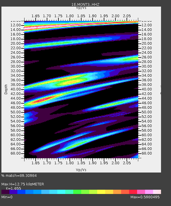
MONT3 Z - Earthquake Result Viewer
| Earthquake location: |
Samoa Islands Region |
| Earthquake latitude/longitude: |
-15.4/-173.0 |
| Earthquake time(UTC): |
2022/12/04 (338) 19:24:15 GMT |
| Earthquake Depth: |
36 km |
| Earthquake Magnitude: |
6.7 Mww |
| Earthquake Catalog/Contributor: |
NEIC PDE/us |
|
| Network: |
1E GSC-BCOGC Induced Seismicity Study |
| Station: |
MONT3 Z |
| Lat/Lon: |
56.01 N/120.45 W |
| Elevation: |
783 m |
|
| Distance: |
83.6 deg |
| Az: |
26.647 deg |
| Baz: |
230.369 deg |
| Ray Param: |
0.04602243 |
| Estimated Moho Depth: |
12.75 km |
| Estimated Crust Vp/Vs: |
1.65 |
| Assumed Crust Vp: |
6.291 km/s |
| Estimated Crust Vs: |
3.801 km/s |
| Estimated Crust Poisson's Ratio: |
0.21 |
|
| Radial Match: |
89.30984 % |
| Radial Bump: |
400 |
| Transverse Match: |
72.34025 % |
| Transverse Bump: |
400 |
| SOD ConfigId: |
29823551 |
| Insert Time: |
2022-12-18 19:24:24.125 +0000 |
| GWidth: |
2.5 |
| Max Bumps: |
400 |
| Tol: |
0.001 |
|

Signal To Noise
| Channel | StoN | STA | LTA |
| 1E:MONT3: :HHZ:20221204T19:36:08.720003Z | 18.69546 | 3.687383E-6 | 1.9723416E-7 |
| 1E:MONT3: :HHN:20221204T19:36:08.720003Z | 3.217216 | 9.979548E-7 | 3.10192E-7 |
| 1E:MONT3: :HHE:20221204T19:36:08.720003Z | 2.7824593 | 1.0881137E-6 | 3.9106186E-7 |
| Arrivals |
| Ps | 1.4 SECOND |
| PpPs | 5.2 SECOND |
| PsPs/PpSs | 6.6 SECOND |


