You are here: Home > Network List > XA95 - Missouri to Massachusetts Transect Stations List
> Station MM13 Spiceland, Indiana > Earthquake Result Viewer
MM13 Spiceland, Indiana - Earthquake Result Viewer
| Earthquake location: |
Egypt |
| Earthquake latitude/longitude: |
28.8/34.9 |
| Earthquake time(UTC): |
1995/11/22 (326) 04:15:11 GMT |
| Earthquake Depth: |
10 km |
| Earthquake Magnitude: |
6.2 MB, 7.3 MS, 7.2 UNKNOWN, 6.2 ML |
| Earthquake Catalog/Contributor: |
WHDF/NEIC |
|
| Network: |
XA Missouri to Massachusetts Transect |
| Station: |
MM13 Spiceland, Indiana |
| Lat/Lon: |
39.83 N/85.31 W |
| Elevation: |
337 m |
|
| Distance: |
91.9 deg |
| Az: |
318.234 deg |
| Baz: |
49.381 deg |
| Ray Param: |
0.041535225 |
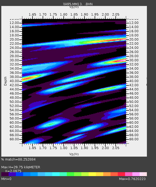
| Estimated Moho Depth: |
29.75 km |
| Estimated Crust Vp/Vs: |
2.10 |
| Assumed Crust Vp: |
6.498 km/s |
| Estimated Crust Vs: |
3.098 km/s |
| Estimated Crust Poisson's Ratio: |
0.35 |
|
| Radial Match: |
88.252884 % |
| Radial Bump: |
400 |
| Transverse Match: |
69.72579 % |
| Transverse Bump: |
400 |
| SOD ConfigId: |
6273 |
| Insert Time: |
2010-02-26 17:53:14.012 +0000 |
| GWidth: |
2.5 |
| Max Bumps: |
400 |
| Tol: |
0.001 |
|

Signal To Noise
| Channel | StoN | STA | LTA |
| XA:MM13: :BHN:19951122T04:27:48.663013Z | 0.99453264 | 2.3233696E-7 | 2.3361422E-7 |
| XA:MM13: :BHE:19951122T04:27:48.663013Z | 0.9861741 | 2.2964716E-7 | 2.3286675E-7 |
| XA:MM13: :BHZ:19951122T04:27:48.663013Z | 2.5426078 | 5.3167753E-7 | 2.0910718E-7 |
| Arrivals |
| Ps | 5.1 SECOND |
| PpPs | 14 SECOND |
| PsPs/PpSs | 19 SECOND |


