You are here: Home > Network List > AG - Arkansas Seismic Network Stations List
> Station XA02 Annieville, Arkansas > Earthquake Result Viewer
XA02 Annieville, Arkansas - Earthquake Result Viewer
| Earthquake location: |
Samoa Islands Region |
| Earthquake latitude/longitude: |
-15.4/-173.0 |
| Earthquake time(UTC): |
2022/12/04 (338) 19:24:15 GMT |
| Earthquake Depth: |
36 km |
| Earthquake Magnitude: |
6.7 Mww |
| Earthquake Catalog/Contributor: |
NEIC PDE/us |
|
| Network: |
AG Arkansas Seismic Network |
| Station: |
XA02 Annieville, Arkansas |
| Lat/Lon: |
36.16 N/91.26 W |
| Elevation: |
190 m |
|
| Distance: |
92.4 deg |
| Az: |
53.273 deg |
| Baz: |
252.812 deg |
| Ray Param: |
0.041447915 |
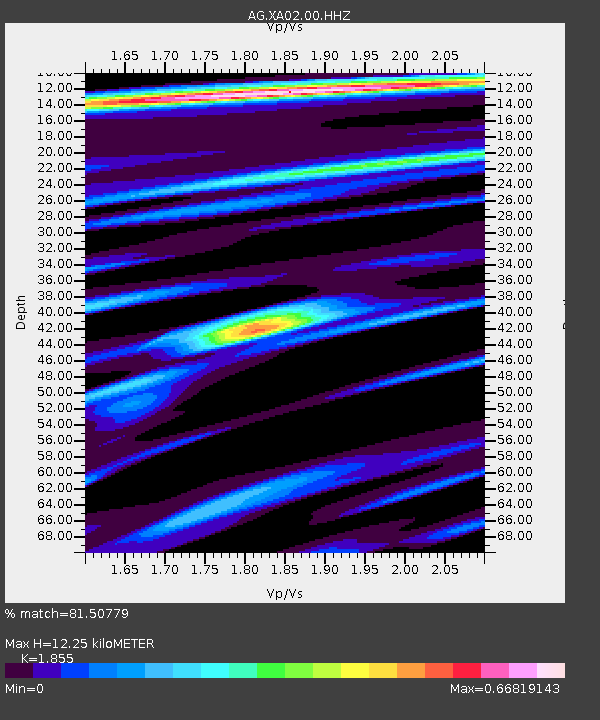
| Estimated Moho Depth: |
12.25 km |
| Estimated Crust Vp/Vs: |
1.86 |
| Assumed Crust Vp: |
6.53 km/s |
| Estimated Crust Vs: |
3.52 km/s |
| Estimated Crust Poisson's Ratio: |
0.30 |
|
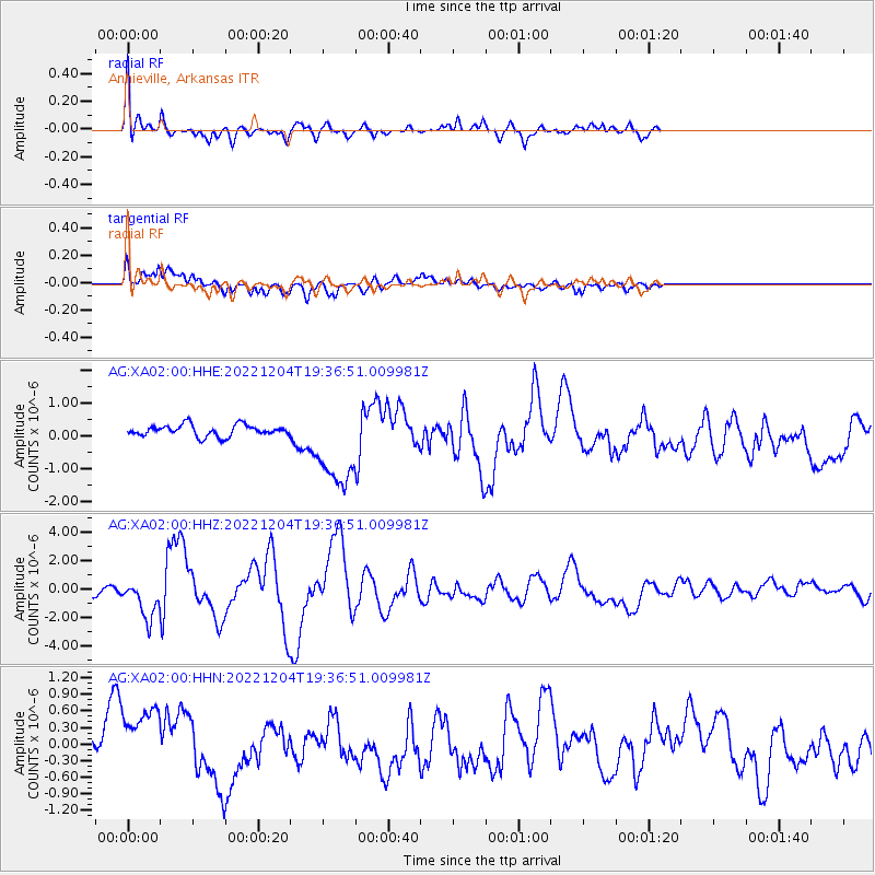
| Radial Match: |
81.50779 % |
| Radial Bump: |
380 |
| Transverse Match: |
53.17493 % |
| Transverse Bump: |
400 |
| SOD ConfigId: |
29823551 |
| Insert Time: |
2022-12-18 19:25:37.278 +0000 |
| GWidth: |
2.5 |
| Max Bumps: |
400 |
| Tol: |
0.001 |
|
Signal To Noise
| Channel | StoN | STA | LTA |
| AG:XA02:00:HHZ:20221204T19:36:51.009981Z | 4.679717 | 1.3669611E-6 | 2.9210338E-7 |
| AG:XA02:00:HHN:20221204T19:36:51.009981Z | 2.097175 | 7.0865786E-7 | 3.379107E-7 |
| AG:XA02:00:HHE:20221204T19:36:51.009981Z | 7.746099 | 1.3302301E-6 | 1.7172903E-7 |
| Arrivals |
| Ps | 1.6 SECOND |
| PpPs | 5.2 SECOND |
| PsPs/PpSs | 6.9 SECOND |


