You are here: Home > Network List > AK - Alaska Regional Network Stations List
> Station CCB Clear Creek Butte, AK, USA > Earthquake Result Viewer
CCB Clear Creek Butte, AK, USA - Earthquake Result Viewer
| Earthquake location: |
Samoa Islands Region |
| Earthquake latitude/longitude: |
-15.4/-173.0 |
| Earthquake time(UTC): |
2022/12/04 (338) 19:24:15 GMT |
| Earthquake Depth: |
36 km |
| Earthquake Magnitude: |
6.7 Mww |
| Earthquake Catalog/Contributor: |
NEIC PDE/us |
|
| Network: |
AK Alaska Regional Network |
| Station: |
CCB Clear Creek Butte, AK, USA |
| Lat/Lon: |
64.65 N/147.81 W |
| Elevation: |
233 m |
|
| Distance: |
82.1 deg |
| Az: |
10.652 deg |
| Baz: |
204.461 deg |
| Ray Param: |
0.047086276 |
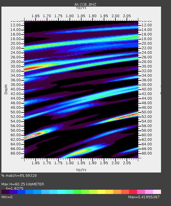
| Estimated Moho Depth: |
60.25 km |
| Estimated Crust Vp/Vs: |
1.63 |
| Assumed Crust Vp: |
6.566 km/s |
| Estimated Crust Vs: |
4.035 km/s |
| Estimated Crust Poisson's Ratio: |
0.20 |
|
| Radial Match: |
95.59328 % |
| Radial Bump: |
376 |
| Transverse Match: |
92.32355 % |
| Transverse Bump: |
400 |
| SOD ConfigId: |
29823551 |
| Insert Time: |
2022-12-18 19:26:29.980 +0000 |
| GWidth: |
2.5 |
| Max Bumps: |
400 |
| Tol: |
0.001 |
|

Signal To Noise
| Channel | StoN | STA | LTA |
| AK:CCB: :BHZ:20221204T19:36:00.860018Z | 13.31573 | 4.834454E-6 | 3.6306338E-7 |
| AK:CCB: :BHN:20221204T19:36:00.860018Z | 8.820693 | 1.5662629E-6 | 1.7756687E-7 |
| AK:CCB: :BHE:20221204T19:36:00.860018Z | 4.4448113 | 1.1724217E-6 | 2.637731E-7 |
| Arrivals |
| Ps | 5.9 SECOND |
| PpPs | 23 SECOND |
| PsPs/PpSs | 29 SECOND |


