You are here: Home > Network List > AK - Alaska Regional Network Stations List
> Station CUT Chulitna, AK, USA > Earthquake Result Viewer
CUT Chulitna, AK, USA - Earthquake Result Viewer

| Earthquake location: |
Samoa Islands Region |
| Earthquake latitude/longitude: |
-15.4/-173.0 |
| Earthquake time(UTC): |
2022/12/04 (338) 19:24:15 GMT |
| Earthquake Depth: |
36 km |
| Earthquake Magnitude: |
6.7 Mww |
| Earthquake Catalog/Contributor: |
NEIC PDE/us |
|
| Network: |
AK Alaska Regional Network |
| Station: |
CUT Chulitna, AK, USA |
| Lat/Lon: |
62.41 N/150.26 W |
| Elevation: |
574 m |
|
| Distance: |
79.6 deg |
| Az: |
10.53 deg |
| Baz: |
202.244 deg |
| Ray Param: |
0.048812024 |
| Estimated Moho Depth: |
31.25 km |
| Estimated Crust Vp/Vs: |
1.76 |
| Assumed Crust Vp: |
6.438 km/s |
| Estimated Crust Vs: |
3.648 km/s |
| Estimated Crust Poisson's Ratio: |
0.26 |
|
| Radial Match: |
85.81029 % |
| Radial Bump: |
400 |
| Transverse Match: |
84.708046 % |
| Transverse Bump: |
400 |
| SOD ConfigId: |
29823551 |
| Insert Time: |
2022-12-18 19:26:41.341 +0000 |
| GWidth: |
2.5 |
| Max Bumps: |
400 |
| Tol: |
0.001 |
|
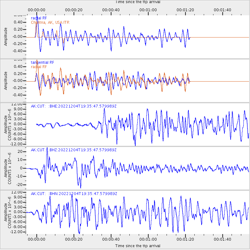
Signal To Noise
| Channel | StoN | STA | LTA |
| AK:CUT: :BHZ:20221204T19:35:47.579989Z | 26.07471 | 6.1628307E-6 | 2.3635279E-7 |
| AK:CUT: :BHN:20221204T19:35:47.579989Z | 6.2433667 | 2.7307422E-6 | 4.3738297E-7 |
| AK:CUT: :BHE:20221204T19:35:47.579989Z | 2.1237059 | 1.4190019E-6 | 6.681725E-7 |
| Arrivals |
| Ps | 3.8 SECOND |
| PpPs | 13 SECOND |
| PsPs/PpSs | 17 SECOND |


