You are here: Home > Network List > AK - Alaska Regional Network Stations List
> Station S31K Pelican, AK, USA > Earthquake Result Viewer
S31K Pelican, AK, USA - Earthquake Result Viewer
| Earthquake location: |
Samoa Islands Region |
| Earthquake latitude/longitude: |
-15.4/-173.0 |
| Earthquake time(UTC): |
2022/12/04 (338) 19:24:15 GMT |
| Earthquake Depth: |
36 km |
| Earthquake Magnitude: |
6.7 Mww |
| Earthquake Catalog/Contributor: |
NEIC PDE/us |
|
| Network: |
AK Alaska Regional Network |
| Station: |
S31K Pelican, AK, USA |
| Lat/Lon: |
57.96 N/136.23 W |
| Elevation: |
34 m |
|
| Distance: |
79.1 deg |
| Az: |
18.946 deg |
| Baz: |
215.979 deg |
| Ray Param: |
0.04913338 |
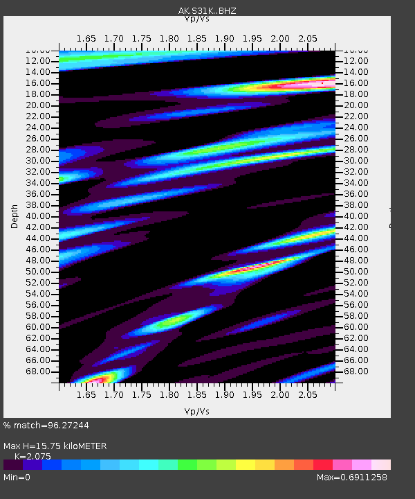
| Estimated Moho Depth: |
15.75 km |
| Estimated Crust Vp/Vs: |
2.08 |
| Assumed Crust Vp: |
6.134 km/s |
| Estimated Crust Vs: |
2.956 km/s |
| Estimated Crust Poisson's Ratio: |
0.35 |
|
| Radial Match: |
96.27244 % |
| Radial Bump: |
366 |
| Transverse Match: |
86.764465 % |
| Transverse Bump: |
400 |
| SOD ConfigId: |
29823551 |
| Insert Time: |
2022-12-18 19:30:04.504 +0000 |
| GWidth: |
2.5 |
| Max Bumps: |
400 |
| Tol: |
0.001 |
|

Signal To Noise
| Channel | StoN | STA | LTA |
| AK:S31K: :BHZ:20221204T19:35:45.06003Z | 18.25665 | 3.3048723E-6 | 1.8102291E-7 |
| AK:S31K: :BHN:20221204T19:35:45.06003Z | 5.5927277 | 1.160407E-6 | 2.0748497E-7 |
| AK:S31K: :BHE:20221204T19:35:45.06003Z | 5.25205 | 9.038461E-7 | 1.7209398E-7 |
| Arrivals |
| Ps | 2.8 SECOND |
| PpPs | 7.7 SECOND |
| PsPs/PpSs | 11 SECOND |


