You are here: Home > Network List > US - United States National Seismic Network Stations List
> Station WMOK Wichita Mountains, Oklahoma, USA > Earthquake Result Viewer
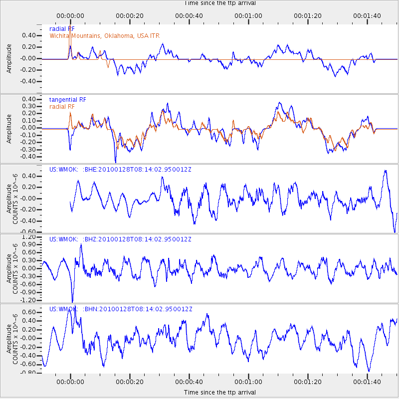
WMOK Wichita Mountains, Oklahoma, USA - Earthquake Result Viewer
*The percent match for this event was below the threshold and hence no stack was calculated.
| Earthquake location: |
Jujuy Province, Argentina |
| Earthquake latitude/longitude: |
-23.4/-66.7 |
| Earthquake time(UTC): |
2010/01/28 (028) 08:04:14 GMT |
| Earthquake Depth: |
208 km |
| Earthquake Magnitude: |
5.8 MB, 5.9 MW, 5.9 MW |
| Earthquake Catalog/Contributor: |
WHDF/NEIC |
|
| Network: |
US United States National Seismic Network |
| Station: |
WMOK Wichita Mountains, Oklahoma, USA |
| Lat/Lon: |
34.74 N/98.78 W |
| Elevation: |
486 m |
|
| Distance: |
65.3 deg |
| Az: |
331.232 deg |
| Baz: |
147.517 deg |
| Ray Param: |
$rayparam |
*The percent match for this event was below the threshold and hence was not used in the summary stack. |
|
| Radial Match: |
34.17476 % |
| Radial Bump: |
400 |
| Transverse Match: |
44.396484 % |
| Transverse Bump: |
400 |
| SOD ConfigId: |
296938 |
| Insert Time: |
2010-04-07 01:05:18.133 +0000 |
| GWidth: |
2.5 |
| Max Bumps: |
400 |
| Tol: |
0.001 |
|
Signal To Noise
| Channel | StoN | STA | LTA |
| US:WMOK: :BHZ:20100128T08:14:02.950012Z | 3.130453 | 5.315848E-7 | 1.6981083E-7 |
| US:WMOK: :BHN:20100128T08:14:02.950012Z | 1.3032268 | 4.1058115E-7 | 3.1504965E-7 |
| US:WMOK: :BHE:20100128T08:14:02.950012Z | 1.383499 | 1.9425414E-7 | 1.4040786E-7 |
| Arrivals |
| Ps | |
| PpPs | |
| PsPs/PpSs | |


