You are here: Home > Network List > AK - Alaska Regional Network Stations List
> Station TGL Tana Glacier > Earthquake Result Viewer
TGL Tana Glacier - Earthquake Result Viewer
| Earthquake location: |
Samoa Islands Region |
| Earthquake latitude/longitude: |
-15.4/-173.0 |
| Earthquake time(UTC): |
2022/12/04 (338) 19:24:15 GMT |
| Earthquake Depth: |
36 km |
| Earthquake Magnitude: |
6.7 Mww |
| Earthquake Catalog/Contributor: |
NEIC PDE/us |
|
| Network: |
AK Alaska Regional Network |
| Station: |
TGL Tana Glacier |
| Lat/Lon: |
60.75 N/142.83 W |
| Elevation: |
1260 m |
|
| Distance: |
79.6 deg |
| Az: |
14.516 deg |
| Baz: |
209.495 deg |
| Ray Param: |
0.048767895 |
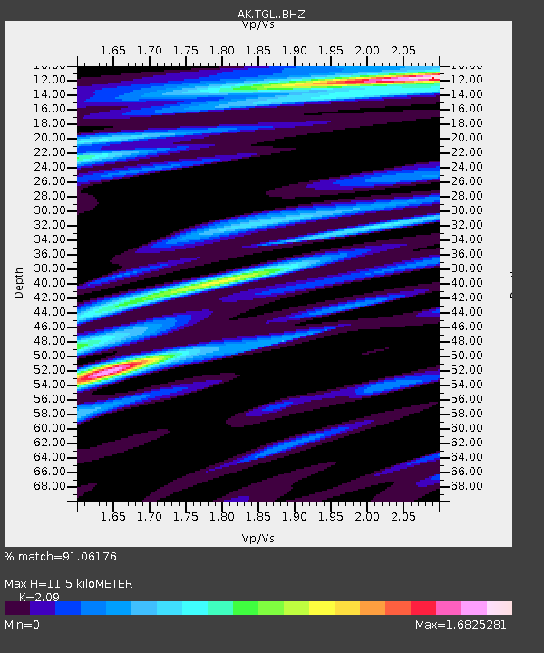
| Estimated Moho Depth: |
11.5 km |
| Estimated Crust Vp/Vs: |
2.09 |
| Assumed Crust Vp: |
6.566 km/s |
| Estimated Crust Vs: |
3.142 km/s |
| Estimated Crust Poisson's Ratio: |
0.35 |
|
| Radial Match: |
91.06176 % |
| Radial Bump: |
400 |
| Transverse Match: |
88.974266 % |
| Transverse Bump: |
400 |
| SOD ConfigId: |
29823551 |
| Insert Time: |
2022-12-18 19:30:26.354 +0000 |
| GWidth: |
2.5 |
| Max Bumps: |
400 |
| Tol: |
0.001 |
|

Signal To Noise
| Channel | StoN | STA | LTA |
| AK:TGL: :BHZ:20221204T19:35:47.920016Z | 18.816835 | 4.083678E-6 | 2.1702256E-7 |
| AK:TGL: :BHN:20221204T19:35:47.920016Z | 2.781094 | 1.391484E-6 | 5.003369E-7 |
| AK:TGL: :BHE:20221204T19:35:47.920016Z | 1.4306766 | 6.0176563E-7 | 4.206161E-7 |
| Arrivals |
| Ps | 2.0 SECOND |
| PpPs | 5.3 SECOND |
| PsPs/PpSs | 7.2 SECOND |


