You are here: Home > Network List > AU - Australian Seismological Centre Stations List
> Station KLGGI Kalgoorlie Hampton Hill, WA, GSWA > Earthquake Result Viewer
KLGGI Kalgoorlie Hampton Hill, WA, GSWA - Earthquake Result Viewer
| Earthquake location: |
Samoa Islands Region |
| Earthquake latitude/longitude: |
-15.4/-173.0 |
| Earthquake time(UTC): |
2022/12/04 (338) 19:24:15 GMT |
| Earthquake Depth: |
36 km |
| Earthquake Magnitude: |
6.7 Mww |
| Earthquake Catalog/Contributor: |
NEIC PDE/us |
|
| Network: |
AU Australian Seismological Centre |
| Station: |
KLGGI Kalgoorlie Hampton Hill, WA, GSWA |
| Lat/Lon: |
30.28 S/121.76 E |
| Elevation: |
385 m |
|
| Distance: |
61.2 deg |
| Az: |
243.69 deg |
| Baz: |
91.687 deg |
| Ray Param: |
0.060951535 |
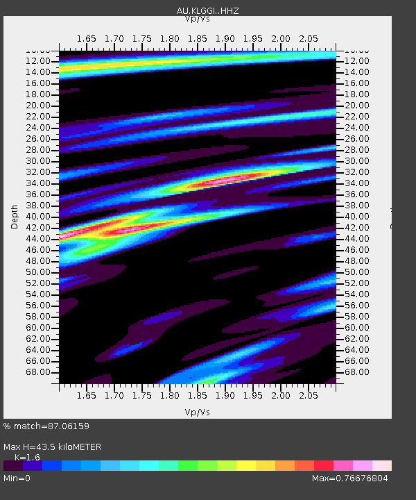
| Estimated Moho Depth: |
43.5 km |
| Estimated Crust Vp/Vs: |
1.60 |
| Assumed Crust Vp: |
6.459 km/s |
| Estimated Crust Vs: |
4.037 km/s |
| Estimated Crust Poisson's Ratio: |
0.18 |
|
| Radial Match: |
87.06159 % |
| Radial Bump: |
382 |
| Transverse Match: |
69.33024 % |
| Transverse Bump: |
400 |
| SOD ConfigId: |
29823551 |
| Insert Time: |
2022-12-18 19:31:42.854 +0000 |
| GWidth: |
2.5 |
| Max Bumps: |
400 |
| Tol: |
0.001 |
|

Signal To Noise
| Channel | StoN | STA | LTA |
| AU:KLGGI: :HHZ:20221204T19:33:55.800021Z | 6.068768 | 1.681549E-6 | 2.7708245E-7 |
| AU:KLGGI: :HHN:20221204T19:33:55.800021Z | 0.6530338 | 1.5445754E-7 | 2.3652305E-7 |
| AU:KLGGI: :HHE:20221204T19:33:55.800021Z | 2.317259 | 6.682049E-7 | 2.8836004E-7 |
| Arrivals |
| Ps | 4.3 SECOND |
| PpPs | 17 SECOND |
| PsPs/PpSs | 21 SECOND |


