You are here: Home > Network List > AU - Australian Seismological Centre Stations List
> Station PSAA1 Pilbara Seismic Array Element A1 > Earthquake Result Viewer
PSAA1 Pilbara Seismic Array Element A1 - Earthquake Result Viewer
| Earthquake location: |
Samoa Islands Region |
| Earthquake latitude/longitude: |
-15.4/-173.0 |
| Earthquake time(UTC): |
2022/12/04 (338) 19:24:15 GMT |
| Earthquake Depth: |
36 km |
| Earthquake Magnitude: |
6.7 Mww |
| Earthquake Catalog/Contributor: |
NEIC PDE/us |
|
| Network: |
AU Australian Seismological Centre |
| Station: |
PSAA1 Pilbara Seismic Array Element A1 |
| Lat/Lon: |
21.58 S/119.84 E |
| Elevation: |
325 m |
|
| Distance: |
63.6 deg |
| Az: |
253.297 deg |
| Baz: |
96.984 deg |
| Ray Param: |
0.0594035 |
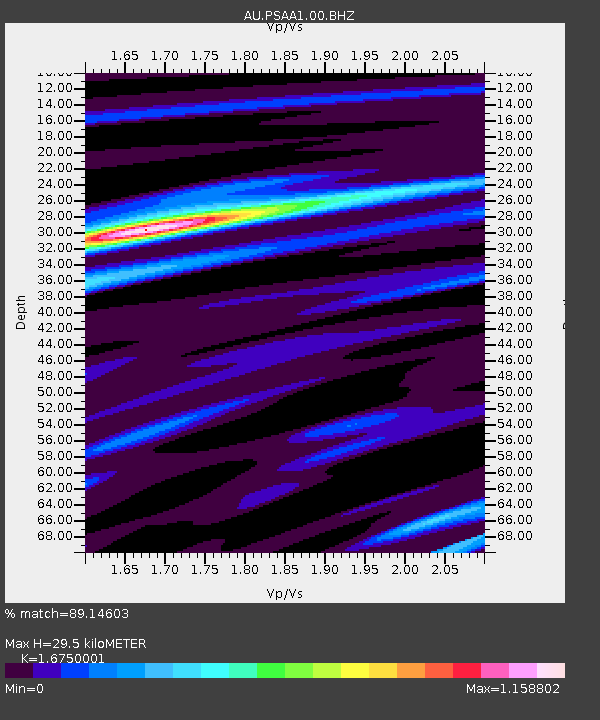
| Estimated Moho Depth: |
29.5 km |
| Estimated Crust Vp/Vs: |
1.68 |
| Assumed Crust Vp: |
6.464 km/s |
| Estimated Crust Vs: |
3.859 km/s |
| Estimated Crust Poisson's Ratio: |
0.22 |
|
| Radial Match: |
89.14603 % |
| Radial Bump: |
400 |
| Transverse Match: |
78.27166 % |
| Transverse Bump: |
400 |
| SOD ConfigId: |
29823551 |
| Insert Time: |
2022-12-18 19:32:08.658 +0000 |
| GWidth: |
2.5 |
| Max Bumps: |
400 |
| Tol: |
0.001 |
|

Signal To Noise
| Channel | StoN | STA | LTA |
| AU:PSAA1:00:BHZ:20221204T19:34:11.769015Z | 7.316211 | 1.3760583E-6 | 1.8808348E-7 |
| AU:PSAA1:00:BH1:20221204T19:34:11.769015Z | 1.3605902 | 6.8777683E-7 | 5.0549886E-7 |
| AU:PSAA1:00:BH2:20221204T19:34:11.769015Z | 4.4840307 | 6.811981E-7 | 1.5191647E-7 |
| Arrivals |
| Ps | 3.2 SECOND |
| PpPs | 12 SECOND |
| PsPs/PpSs | 15 SECOND |


