You are here: Home > Network List > AU - Australian Seismological Centre Stations List
> Station PSAC1 Pilbara Seismic Array Element C1 > Earthquake Result Viewer
PSAC1 Pilbara Seismic Array Element C1 - Earthquake Result Viewer
| Earthquake location: |
Samoa Islands Region |
| Earthquake latitude/longitude: |
-15.4/-173.0 |
| Earthquake time(UTC): |
2022/12/04 (338) 19:24:15 GMT |
| Earthquake Depth: |
36 km |
| Earthquake Magnitude: |
6.7 Mww |
| Earthquake Catalog/Contributor: |
NEIC PDE/us |
|
| Network: |
AU Australian Seismological Centre |
| Station: |
PSAC1 Pilbara Seismic Array Element C1 |
| Lat/Lon: |
21.53 S/119.81 E |
| Elevation: |
303 m |
|
| Distance: |
63.6 deg |
| Az: |
253.341 deg |
| Baz: |
97.013 deg |
| Ray Param: |
0.059384953 |
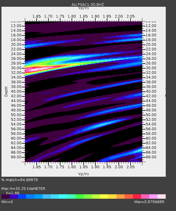
| Estimated Moho Depth: |
30.25 km |
| Estimated Crust Vp/Vs: |
1.66 |
| Assumed Crust Vp: |
6.464 km/s |
| Estimated Crust Vs: |
3.894 km/s |
| Estimated Crust Poisson's Ratio: |
0.22 |
|
| Radial Match: |
94.69979 % |
| Radial Bump: |
255 |
| Transverse Match: |
79.077644 % |
| Transverse Bump: |
400 |
| SOD ConfigId: |
29823551 |
| Insert Time: |
2022-12-18 19:32:17.637 +0000 |
| GWidth: |
2.5 |
| Max Bumps: |
400 |
| Tol: |
0.001 |
|

Signal To Noise
| Channel | StoN | STA | LTA |
| AU:PSAC1:00:BHZ:20221204T19:34:11.969027Z | 6.9742346 | 1.4308979E-6 | 2.0516917E-7 |
| AU:PSAC1:00:BH1:20221204T19:34:11.969027Z | 1.3515356 | 1.8552498E-7 | 1.3726978E-7 |
| AU:PSAC1:00:BH2:20221204T19:34:11.969027Z | 4.521682 | 6.4811906E-7 | 1.4333584E-7 |
| Arrivals |
| Ps | 3.2 SECOND |
| PpPs | 12 SECOND |
| PsPs/PpSs | 15 SECOND |


