You are here: Home > Network List > AV - Alaska Volcano Observatory Stations List
> Station ANPB Aniakchak Pleny Bear, Alaska > Earthquake Result Viewer
ANPB Aniakchak Pleny Bear, Alaska - Earthquake Result Viewer

| Earthquake location: |
Samoa Islands Region |
| Earthquake latitude/longitude: |
-15.4/-173.0 |
| Earthquake time(UTC): |
2022/12/04 (338) 19:24:15 GMT |
| Earthquake Depth: |
36 km |
| Earthquake Magnitude: |
6.7 Mww |
| Earthquake Catalog/Contributor: |
NEIC PDE/us |
|
| Network: |
AV Alaska Volcano Observatory |
| Station: |
ANPB Aniakchak Pleny Bear, Alaska |
| Lat/Lon: |
56.80 N/158.28 W |
| Elevation: |
662 m |
|
| Distance: |
73.0 deg |
| Az: |
8.387 deg |
| Baz: |
194.818 deg |
| Ray Param: |
0.053266298 |
| Estimated Moho Depth: |
36.5 km |
| Estimated Crust Vp/Vs: |
1.72 |
| Assumed Crust Vp: |
6.134 km/s |
| Estimated Crust Vs: |
3.577 km/s |
| Estimated Crust Poisson's Ratio: |
0.24 |
|
| Radial Match: |
84.016266 % |
| Radial Bump: |
400 |
| Transverse Match: |
65.38375 % |
| Transverse Bump: |
400 |
| SOD ConfigId: |
29823551 |
| Insert Time: |
2022-12-18 19:32:54.661 +0000 |
| GWidth: |
2.5 |
| Max Bumps: |
400 |
| Tol: |
0.001 |
|
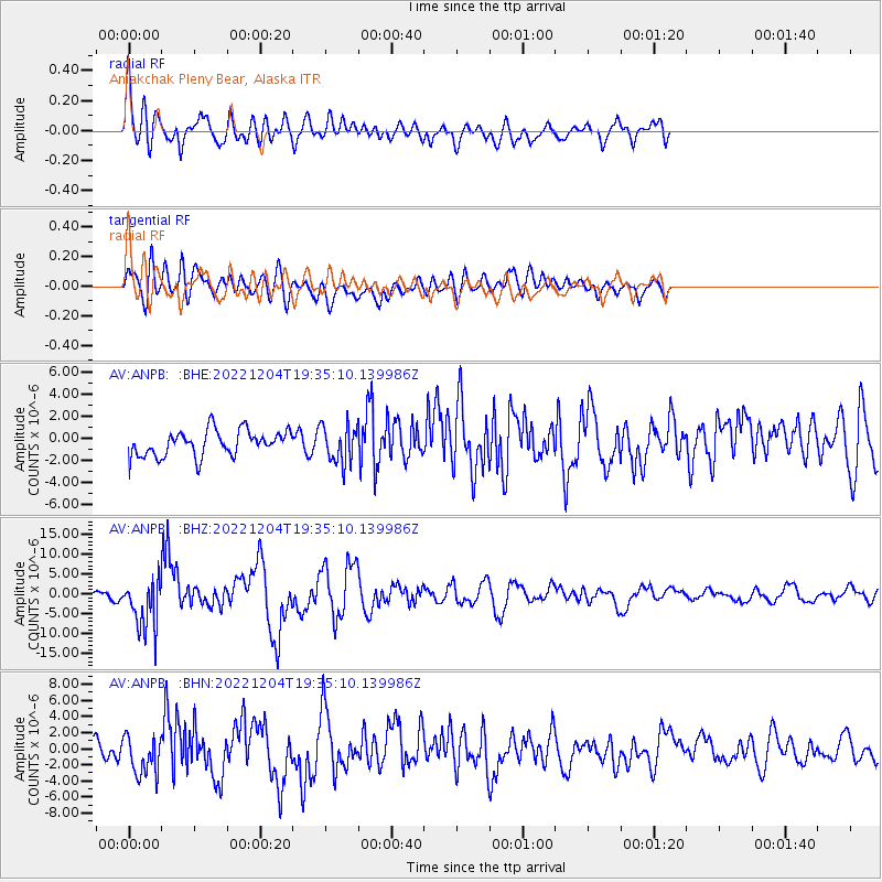
Signal To Noise
| Channel | StoN | STA | LTA |
| AV:ANPB: :BHZ:20221204T19:35:10.139986Z | 8.857834 | 6.284573E-6 | 7.0949324E-7 |
| AV:ANPB: :BHN:20221204T19:35:10.139986Z | 1.7387887 | 2.4335545E-6 | 1.3995689E-6 |
| AV:ANPB: :BHE:20221204T19:35:10.139986Z | 1.4358101 | 1.6689714E-6 | 1.1623902E-6 |
| Arrivals |
| Ps | 4.4 SECOND |
| PpPs | 16 SECOND |
| PsPs/PpSs | 20 SECOND |


