You are here: Home > Network List > AV - Alaska Volcano Observatory Stations List
> Station CAHL Cahill, Katmai, Alaska > Earthquake Result Viewer
CAHL Cahill, Katmai, Alaska - Earthquake Result Viewer
| Earthquake location: |
Samoa Islands Region |
| Earthquake latitude/longitude: |
-15.4/-173.0 |
| Earthquake time(UTC): |
2022/12/04 (338) 19:24:15 GMT |
| Earthquake Depth: |
36 km |
| Earthquake Magnitude: |
6.7 Mww |
| Earthquake Catalog/Contributor: |
NEIC PDE/us |
|
| Network: |
AV Alaska Volcano Observatory |
| Station: |
CAHL Cahill, Katmai, Alaska |
| Lat/Lon: |
58.05 N/155.30 W |
| Elevation: |
807 m |
|
| Distance: |
74.6 deg |
| Az: |
9.633 deg |
| Baz: |
197.671 deg |
| Ray Param: |
0.05216212 |
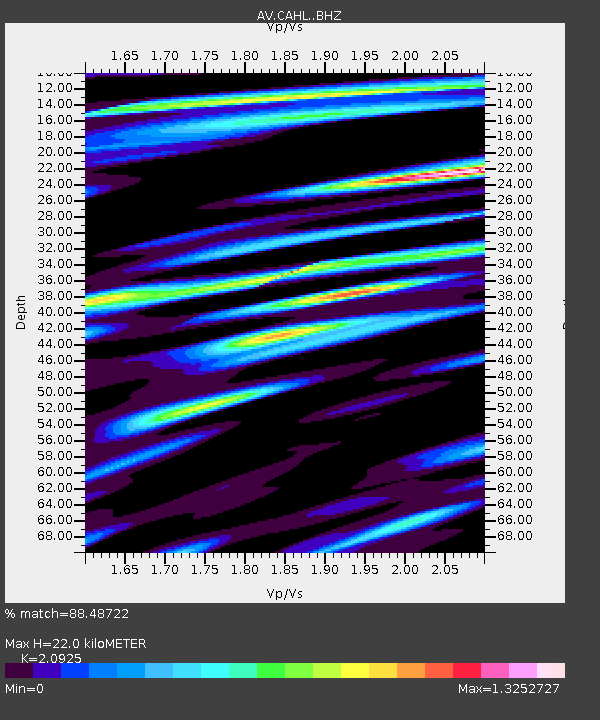
| Estimated Moho Depth: |
22.0 km |
| Estimated Crust Vp/Vs: |
2.09 |
| Assumed Crust Vp: |
6.438 km/s |
| Estimated Crust Vs: |
3.077 km/s |
| Estimated Crust Poisson's Ratio: |
0.35 |
|
| Radial Match: |
88.48722 % |
| Radial Bump: |
400 |
| Transverse Match: |
71.60298 % |
| Transverse Bump: |
400 |
| SOD ConfigId: |
29823551 |
| Insert Time: |
2022-12-18 19:33:21.773 +0000 |
| GWidth: |
2.5 |
| Max Bumps: |
400 |
| Tol: |
0.001 |
|

Signal To Noise
| Channel | StoN | STA | LTA |
| AV:CAHL: :BHZ:20221204T19:35:19.800021Z | 4.124831 | 5.269825E-6 | 1.2775856E-6 |
| AV:CAHL: :BHN:20221204T19:35:19.800021Z | 2.1998153 | 2.0825798E-6 | 9.467067E-7 |
| AV:CAHL: :BHE:20221204T19:35:19.800021Z | 1.2229897 | 9.672186E-7 | 7.9086414E-7 |
| Arrivals |
| Ps | 3.8 SECOND |
| PpPs | 10 SECOND |
| PsPs/PpSs | 14 SECOND |


