You are here: Home > Network List > AV - Alaska Volcano Observatory Stations List
> Station KAPH Katmai Pasha, Alaska > Earthquake Result Viewer
KAPH Katmai Pasha, Alaska - Earthquake Result Viewer
| Earthquake location: |
Samoa Islands Region |
| Earthquake latitude/longitude: |
-15.4/-173.0 |
| Earthquake time(UTC): |
2022/12/04 (338) 19:24:15 GMT |
| Earthquake Depth: |
36 km |
| Earthquake Magnitude: |
6.7 Mww |
| Earthquake Catalog/Contributor: |
NEIC PDE/us |
|
| Network: |
AV Alaska Volcano Observatory |
| Station: |
KAPH Katmai Pasha, Alaska |
| Lat/Lon: |
58.60 N/154.35 W |
| Elevation: |
907 m |
|
| Distance: |
75.3 deg |
| Az: |
9.953 deg |
| Baz: |
198.565 deg |
| Ray Param: |
0.051715445 |
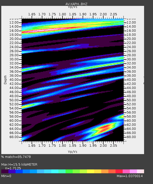
| Estimated Moho Depth: |
15.5 km |
| Estimated Crust Vp/Vs: |
1.71 |
| Assumed Crust Vp: |
6.438 km/s |
| Estimated Crust Vs: |
3.76 km/s |
| Estimated Crust Poisson's Ratio: |
0.24 |
|
| Radial Match: |
85.7479 % |
| Radial Bump: |
400 |
| Transverse Match: |
78.3222 % |
| Transverse Bump: |
400 |
| SOD ConfigId: |
29823551 |
| Insert Time: |
2022-12-18 19:34:20.723 +0000 |
| GWidth: |
2.5 |
| Max Bumps: |
400 |
| Tol: |
0.001 |
|

Signal To Noise
| Channel | StoN | STA | LTA |
| AV:KAPH: :BHZ:20221204T19:35:23.699984Z | 7.71777 | 4.82477E-6 | 6.251508E-7 |
| AV:KAPH: :BHN:20221204T19:35:23.699984Z | 2.3871515 | 1.8075525E-6 | 7.5720055E-7 |
| AV:KAPH: :BHE:20221204T19:35:23.699984Z | 1.6189551 | 1.0813056E-6 | 6.679034E-7 |
| Arrivals |
| Ps | 1.8 SECOND |
| PpPs | 6.3 SECOND |
| PsPs/PpSs | 8.1 SECOND |


