You are here: Home > Network List > US - United States National Seismic Network Stations List
> Station MNTX Cornudas Mountains, Texas, USA > Earthquake Result Viewer
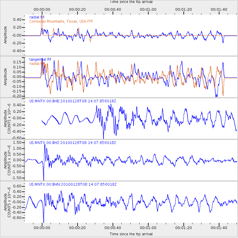
MNTX Cornudas Mountains, Texas, USA - Earthquake Result Viewer
*The percent match for this event was below the threshold and hence no stack was calculated.
| Earthquake location: |
Jujuy Province, Argentina |
| Earthquake latitude/longitude: |
-23.4/-66.7 |
| Earthquake time(UTC): |
2010/01/28 (028) 08:04:14 GMT |
| Earthquake Depth: |
208 km |
| Earthquake Magnitude: |
5.8 MB, 5.9 MW, 5.9 MW |
| Earthquake Catalog/Contributor: |
WHDF/NEIC |
|
| Network: |
US United States National Seismic Network |
| Station: |
MNTX Cornudas Mountains, Texas, USA |
| Lat/Lon: |
31.70 N/105.38 W |
| Elevation: |
404 m |
|
| Distance: |
66.1 deg |
| Az: |
324.362 deg |
| Baz: |
141.083 deg |
| Ray Param: |
$rayparam |
*The percent match for this event was below the threshold and hence was not used in the summary stack. |
|
| Radial Match: |
65.389656 % |
| Radial Bump: |
400 |
| Transverse Match: |
72.16063 % |
| Transverse Bump: |
400 |
| SOD ConfigId: |
296938 |
| Insert Time: |
2010-04-07 01:08:04.404 +0000 |
| GWidth: |
2.5 |
| Max Bumps: |
400 |
| Tol: |
0.001 |
|
Signal To Noise
| Channel | StoN | STA | LTA |
| US:MNTX:00:BHZ:20100128T08:14:07.856018Z | 3.4914296 | 6.2648377E-7 | 1.7943474E-7 |
| US:MNTX:00:BHN:20100128T08:14:07.856018Z | 1.971054 | 2.4510373E-7 | 1.2435162E-7 |
| US:MNTX:00:BHE:20100128T08:14:07.856018Z | 2.2497308 | 2.2168379E-7 | 9.853792E-8 |
| Arrivals |
| Ps | |
| PpPs | |
| PsPs/PpSs | |


