You are here: Home > Network List > AV - Alaska Volcano Observatory Stations List
> Station KJL Kejulik, Katmai, Alaska > Earthquake Result Viewer
KJL Kejulik, Katmai, Alaska - Earthquake Result Viewer

| Earthquake location: |
Samoa Islands Region |
| Earthquake latitude/longitude: |
-15.4/-173.0 |
| Earthquake time(UTC): |
2022/12/04 (338) 19:24:15 GMT |
| Earthquake Depth: |
36 km |
| Earthquake Magnitude: |
6.7 Mww |
| Earthquake Catalog/Contributor: |
NEIC PDE/us |
|
| Network: |
AV Alaska Volcano Observatory |
| Station: |
KJL Kejulik, Katmai, Alaska |
| Lat/Lon: |
58.05 N/155.58 W |
| Elevation: |
792 m |
|
| Distance: |
74.6 deg |
| Az: |
9.49 deg |
| Baz: |
197.403 deg |
| Ray Param: |
0.052191325 |
| Estimated Moho Depth: |
16.75 km |
| Estimated Crust Vp/Vs: |
1.89 |
| Assumed Crust Vp: |
6.438 km/s |
| Estimated Crust Vs: |
3.406 km/s |
| Estimated Crust Poisson's Ratio: |
0.31 |
|
| Radial Match: |
83.044044 % |
| Radial Bump: |
400 |
| Transverse Match: |
83.435074 % |
| Transverse Bump: |
400 |
| SOD ConfigId: |
29823551 |
| Insert Time: |
2022-12-18 19:34:38.925 +0000 |
| GWidth: |
2.5 |
| Max Bumps: |
400 |
| Tol: |
0.001 |
|
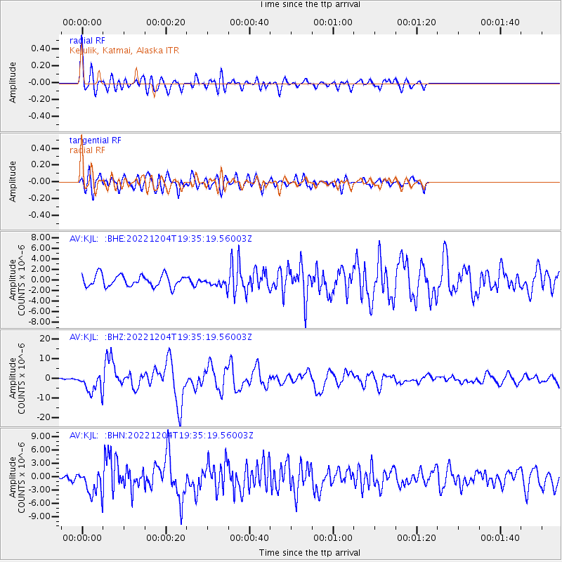
Signal To Noise
| Channel | StoN | STA | LTA |
| AV:KJL: :BHZ:20221204T19:35:19.56003Z | 7.9138284 | 4.992292E-6 | 6.3083144E-7 |
| AV:KJL: :BHN:20221204T19:35:19.56003Z | 3.5944228 | 2.7201975E-6 | 7.5678287E-7 |
| AV:KJL: :BHE:20221204T19:35:19.56003Z | 0.775156 | 8.467634E-7 | 1.092378E-6 |
| Arrivals |
| Ps | 2.4 SECOND |
| PpPs | 7.3 SECOND |
| PsPs/PpSs | 9.7 SECOND |


