You are here: Home > Network List > AZ - ANZA Regional Network Stations List
> Station SMER AZ.SMER > Earthquake Result Viewer
SMER AZ.SMER - Earthquake Result Viewer
| Earthquake location: |
Samoa Islands Region |
| Earthquake latitude/longitude: |
-15.4/-173.0 |
| Earthquake time(UTC): |
2022/12/04 (338) 19:24:15 GMT |
| Earthquake Depth: |
36 km |
| Earthquake Magnitude: |
6.7 Mww |
| Earthquake Catalog/Contributor: |
NEIC PDE/us |
|
| Network: |
AZ ANZA Regional Network |
| Station: |
SMER AZ.SMER |
| Lat/Lon: |
33.46 N/117.17 W |
| Elevation: |
355 m |
|
| Distance: |
72.0 deg |
| Az: |
46.623 deg |
| Baz: |
236.997 deg |
| Ray Param: |
0.0538815 |
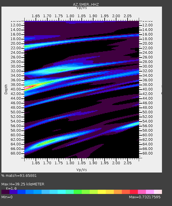
| Estimated Moho Depth: |
39.25 km |
| Estimated Crust Vp/Vs: |
1.60 |
| Assumed Crust Vp: |
6.264 km/s |
| Estimated Crust Vs: |
3.915 km/s |
| Estimated Crust Poisson's Ratio: |
0.18 |
|
| Radial Match: |
93.65881 % |
| Radial Bump: |
285 |
| Transverse Match: |
90.5557 % |
| Transverse Bump: |
339 |
| SOD ConfigId: |
29823551 |
| Insert Time: |
2022-12-18 19:36:51.383 +0000 |
| GWidth: |
2.5 |
| Max Bumps: |
400 |
| Tol: |
0.001 |
|
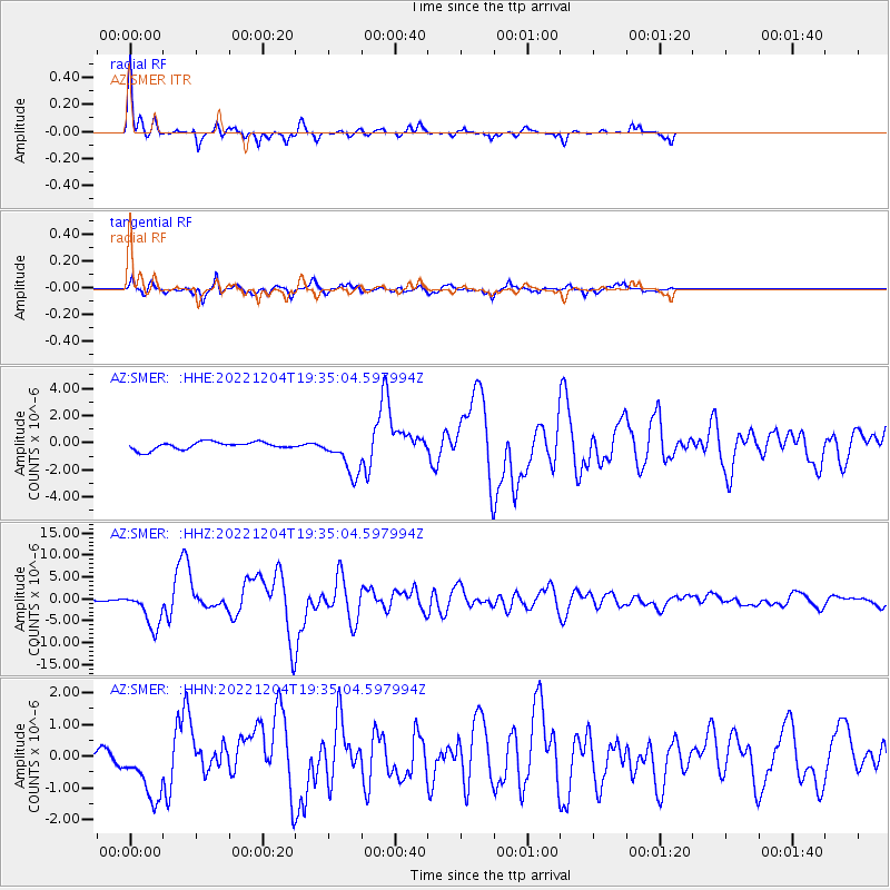
Signal To Noise
| Channel | StoN | STA | LTA |
| AZ:SMER: :HHZ:20221204T19:35:04.597994Z | 20.001003 | 4.2014967E-6 | 2.100643E-7 |
| AZ:SMER: :HHN:20221204T19:35:04.597994Z | 2.8374126 | 9.656464E-7 | 3.403264E-7 |
| AZ:SMER: :HHE:20221204T19:35:04.597994Z | 5.189098 | 1.4576013E-6 | 2.8089687E-7 |
| Arrivals |
| Ps | 3.9 SECOND |
| PpPs | 16 SECOND |
| PsPs/PpSs | 20 SECOND |


