You are here: Home > Network List > AK - Alaska Regional Network Stations List
> Station ANM Anvil Mountian > Earthquake Result Viewer
ANM Anvil Mountian - Earthquake Result Viewer
| Earthquake location: |
Samoa Islands Region |
| Earthquake latitude/longitude: |
-15.7/-172.5 |
| Earthquake time(UTC): |
2022/12/04 (338) 19:24:27 GMT |
| Earthquake Depth: |
148 km |
| Earthquake Magnitude: |
6.9 Mi |
| Earthquake Catalog/Contributor: |
NEIC PDE/at |
|
| Network: |
AK Alaska Regional Network |
| Station: |
ANM Anvil Mountian |
| Lat/Lon: |
64.56 N/165.37 W |
| Elevation: |
330 m |
|
| Distance: |
80.2 deg |
| Az: |
3.119 deg |
| Baz: |
186.968 deg |
| Ray Param: |
0.048094112 |
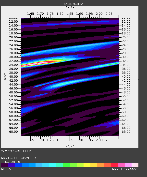
| Estimated Moho Depth: |
33.0 km |
| Estimated Crust Vp/Vs: |
1.68 |
| Assumed Crust Vp: |
6.276 km/s |
| Estimated Crust Vs: |
3.73 km/s |
| Estimated Crust Poisson's Ratio: |
0.23 |
|
| Radial Match: |
91.88385 % |
| Radial Bump: |
396 |
| Transverse Match: |
73.58037 % |
| Transverse Bump: |
400 |
| SOD ConfigId: |
29823551 |
| Insert Time: |
2022-12-18 19:41:47.193 +0000 |
| GWidth: |
2.5 |
| Max Bumps: |
400 |
| Tol: |
0.001 |
|

Signal To Noise
| Channel | StoN | STA | LTA |
| AK:ANM: :BHZ:20221204T19:35:49.900024Z | 6.9184365 | 4.6011874E-6 | 6.650617E-7 |
| AK:ANM: :BHN:20221204T19:35:49.900024Z | 2.5475082 | 1.5892552E-6 | 6.23847E-7 |
| AK:ANM: :BHE:20221204T19:35:49.900024Z | 0.41650754 | 3.36231E-7 | 8.0726267E-7 |
| Arrivals |
| Ps | 3.7 SECOND |
| PpPs | 14 SECOND |
| PsPs/PpSs | 17 SECOND |


