You are here: Home > Network List > AK - Alaska Regional Network Stations List
> Station BARN Barnard Glacier, AK, USA > Earthquake Result Viewer
BARN Barnard Glacier, AK, USA - Earthquake Result Viewer
| Earthquake location: |
Samoa Islands Region |
| Earthquake latitude/longitude: |
-15.7/-172.5 |
| Earthquake time(UTC): |
2022/12/04 (338) 19:24:27 GMT |
| Earthquake Depth: |
148 km |
| Earthquake Magnitude: |
6.9 Mi |
| Earthquake Catalog/Contributor: |
NEIC PDE/at |
|
| Network: |
AK Alaska Regional Network |
| Station: |
BARN Barnard Glacier, AK, USA |
| Lat/Lon: |
61.06 N/141.66 W |
| Elevation: |
1689 m |
|
| Distance: |
80.4 deg |
| Az: |
14.649 deg |
| Baz: |
210.052 deg |
| Ray Param: |
0.047976997 |
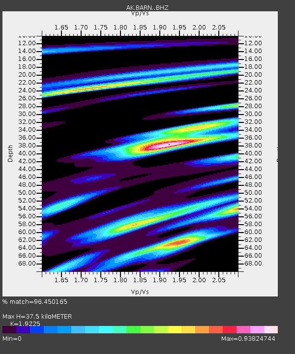
| Estimated Moho Depth: |
37.5 km |
| Estimated Crust Vp/Vs: |
1.92 |
| Assumed Crust Vp: |
6.566 km/s |
| Estimated Crust Vs: |
3.415 km/s |
| Estimated Crust Poisson's Ratio: |
0.31 |
|
| Radial Match: |
96.450165 % |
| Radial Bump: |
374 |
| Transverse Match: |
81.33488 % |
| Transverse Bump: |
400 |
| SOD ConfigId: |
29823551 |
| Insert Time: |
2022-12-18 19:41:58.884 +0000 |
| GWidth: |
2.5 |
| Max Bumps: |
400 |
| Tol: |
0.001 |
|

Signal To Noise
| Channel | StoN | STA | LTA |
| AK:BARN: :BHZ:20221204T19:35:50.799988Z | 23.374413 | 4.030136E-6 | 1.7241656E-7 |
| AK:BARN: :BHN:20221204T19:35:50.799988Z | 9.737788 | 1.4332404E-6 | 1.4718336E-7 |
| AK:BARN: :BHE:20221204T19:35:50.799988Z | 5.986741 | 9.4187686E-7 | 1.5732714E-7 |
| Arrivals |
| Ps | 5.4 SECOND |
| PpPs | 16 SECOND |
| PsPs/PpSs | 22 SECOND |


