You are here: Home > Network List > AK - Alaska Regional Network Stations List
> Station BMR Bremner River > Earthquake Result Viewer
BMR Bremner River - Earthquake Result Viewer
| Earthquake location: |
Samoa Islands Region |
| Earthquake latitude/longitude: |
-15.7/-172.5 |
| Earthquake time(UTC): |
2022/12/04 (338) 19:24:27 GMT |
| Earthquake Depth: |
148 km |
| Earthquake Magnitude: |
6.9 Mi |
| Earthquake Catalog/Contributor: |
NEIC PDE/at |
|
| Network: |
AK Alaska Regional Network |
| Station: |
BMR Bremner River |
| Lat/Lon: |
60.97 N/144.60 W |
| Elevation: |
842 m |
|
| Distance: |
79.6 deg |
| Az: |
13.417 deg |
| Baz: |
207.269 deg |
| Ray Param: |
0.04850072 |
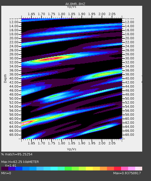
| Estimated Moho Depth: |
62.25 km |
| Estimated Crust Vp/Vs: |
1.61 |
| Assumed Crust Vp: |
6.566 km/s |
| Estimated Crust Vs: |
4.078 km/s |
| Estimated Crust Poisson's Ratio: |
0.19 |
|
| Radial Match: |
95.25254 % |
| Radial Bump: |
400 |
| Transverse Match: |
92.556076 % |
| Transverse Bump: |
400 |
| SOD ConfigId: |
29823551 |
| Insert Time: |
2022-12-18 19:42:07.349 +0000 |
| GWidth: |
2.5 |
| Max Bumps: |
400 |
| Tol: |
0.001 |
|

Signal To Noise
| Channel | StoN | STA | LTA |
| AK:BMR: :BHZ:20221204T19:35:46.679993Z | 14.062928 | 3.899374E-6 | 2.7728035E-7 |
| AK:BMR: :BHN:20221204T19:35:46.679993Z | 3.732241 | 1.1352121E-6 | 3.0416368E-7 |
| AK:BMR: :BHE:20221204T19:35:46.679993Z | 4.70628 | 1.6618361E-6 | 3.5311032E-7 |
| Arrivals |
| Ps | 6.0 SECOND |
| PpPs | 24 SECOND |
| PsPs/PpSs | 30 SECOND |


