You are here: Home > Network List > AK - Alaska Regional Network Stations List
> Station F18K Selawik, AK, USA > Earthquake Result Viewer
F18K Selawik, AK, USA - Earthquake Result Viewer
| Earthquake location: |
Samoa Islands Region |
| Earthquake latitude/longitude: |
-15.7/-172.5 |
| Earthquake time(UTC): |
2022/12/04 (338) 19:24:27 GMT |
| Earthquake Depth: |
148 km |
| Earthquake Magnitude: |
6.9 Mi |
| Earthquake Catalog/Contributor: |
NEIC PDE/at |
|
| Network: |
AK Alaska Regional Network |
| Station: |
F18K Selawik, AK, USA |
| Lat/Lon: |
66.60 N/159.65 W |
| Elevation: |
27 m |
|
| Distance: |
82.6 deg |
| Az: |
5.138 deg |
| Baz: |
192.473 deg |
| Ray Param: |
0.046424035 |
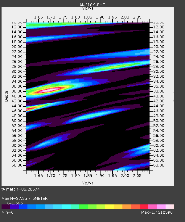
| Estimated Moho Depth: |
37.25 km |
| Estimated Crust Vp/Vs: |
1.70 |
| Assumed Crust Vp: |
6.577 km/s |
| Estimated Crust Vs: |
3.88 km/s |
| Estimated Crust Poisson's Ratio: |
0.23 |
|
| Radial Match: |
86.20574 % |
| Radial Bump: |
374 |
| Transverse Match: |
67.660255 % |
| Transverse Bump: |
400 |
| SOD ConfigId: |
29823551 |
| Insert Time: |
2022-12-18 19:43:12.024 +0000 |
| GWidth: |
2.5 |
| Max Bumps: |
400 |
| Tol: |
0.001 |
|

Signal To Noise
| Channel | StoN | STA | LTA |
| AK:F18K: :BHZ:20221204T19:36:02.559998Z | 7.047056 | 3.5262083E-6 | 5.0038034E-7 |
| AK:F18K: :BHN:20221204T19:36:02.559998Z | 2.061979 | 1.3635787E-6 | 6.612961E-7 |
| AK:F18K: :BHE:20221204T19:36:02.559998Z | 1.2408453 | 1.1922442E-6 | 9.608323E-7 |
| Arrivals |
| Ps | 4.0 SECOND |
| PpPs | 15 SECOND |
| PsPs/PpSs | 19 SECOND |


