You are here: Home > Network List > AK - Alaska Regional Network Stations List
> Station I27K Kandik River, AK, USA > Earthquake Result Viewer
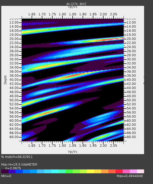
I27K Kandik River, AK, USA - Earthquake Result Viewer
| Earthquake location: |
Samoa Islands Region |
| Earthquake latitude/longitude: |
-15.7/-172.5 |
| Earthquake time(UTC): |
2022/12/04 (338) 19:24:27 GMT |
| Earthquake Depth: |
148 km |
| Earthquake Magnitude: |
6.9 Mi |
| Earthquake Catalog/Contributor: |
NEIC PDE/at |
|
| Network: |
AK Alaska Regional Network |
| Station: |
I27K Kandik River, AK, USA |
| Lat/Lon: |
65.60 N/141.62 W |
| Elevation: |
874 m |
|
| Distance: |
84.3 deg |
| Az: |
12.372 deg |
| Baz: |
209.79 deg |
| Ray Param: |
0.045219783 |
| Estimated Moho Depth: |
19.5 km |
| Estimated Crust Vp/Vs: |
2.10 |
| Assumed Crust Vp: |
6.566 km/s |
| Estimated Crust Vs: |
3.13 km/s |
| Estimated Crust Poisson's Ratio: |
0.35 |
|
| Radial Match: |
86.82911 % |
| Radial Bump: |
400 |
| Transverse Match: |
78.902176 % |
| Transverse Bump: |
400 |
| SOD ConfigId: |
29823551 |
| Insert Time: |
2022-12-18 19:44:06.321 +0000 |
| GWidth: |
2.5 |
| Max Bumps: |
400 |
| Tol: |
0.001 |
|

Signal To Noise
| Channel | StoN | STA | LTA |
| AK:I27K: :BHZ:20221204T19:36:11.299988Z | 23.66351 | 3.46101E-6 | 1.4625937E-7 |
| AK:I27K: :BHN:20221204T19:36:11.299988Z | 4.9639153 | 1.2452366E-6 | 2.5085774E-7 |
| AK:I27K: :BHE:20221204T19:36:11.299988Z | 1.6474077 | 5.9591656E-7 | 3.617299E-7 |
| Arrivals |
| Ps | 3.3 SECOND |
| PpPs | 9.0 SECOND |
| PsPs/PpSs | 12 SECOND |


