You are here: Home > Network List > AK - Alaska Regional Network Stations List
> Station L22K Petersville, AK, USA > Earthquake Result Viewer
L22K Petersville, AK, USA - Earthquake Result Viewer
| Earthquake location: |
Samoa Islands Region |
| Earthquake latitude/longitude: |
-15.7/-172.5 |
| Earthquake time(UTC): |
2022/12/04 (338) 19:24:27 GMT |
| Earthquake Depth: |
148 km |
| Earthquake Magnitude: |
6.9 Mi |
| Earthquake Catalog/Contributor: |
NEIC PDE/at |
|
| Network: |
AK Alaska Regional Network |
| Station: |
L22K Petersville, AK, USA |
| Lat/Lon: |
62.53 N/150.77 W |
| Elevation: |
817 m |
|
| Distance: |
79.8 deg |
| Az: |
10.047 deg |
| Baz: |
201.241 deg |
| Ray Param: |
0.04835011 |
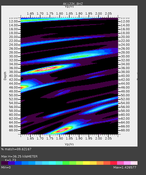
| Estimated Moho Depth: |
36.25 km |
| Estimated Crust Vp/Vs: |
1.73 |
| Assumed Crust Vp: |
6.438 km/s |
| Estimated Crust Vs: |
3.722 km/s |
| Estimated Crust Poisson's Ratio: |
0.25 |
|
| Radial Match: |
89.62167 % |
| Radial Bump: |
400 |
| Transverse Match: |
84.88047 % |
| Transverse Bump: |
400 |
| SOD ConfigId: |
29823551 |
| Insert Time: |
2022-12-18 19:44:51.942 +0000 |
| GWidth: |
2.5 |
| Max Bumps: |
400 |
| Tol: |
0.001 |
|

Signal To Noise
| Channel | StoN | STA | LTA |
| AK:L22K: :BHZ:20221204T19:35:47.859985Z | 15.188827 | 5.0513245E-6 | 3.3256848E-7 |
| AK:L22K: :BHN:20221204T19:35:47.859985Z | 4.7679014 | 1.8399863E-6 | 3.8591116E-7 |
| AK:L22K: :BHE:20221204T19:35:47.859985Z | 5.3994007 | 1.3143599E-6 | 2.4342697E-7 |
| Arrivals |
| Ps | 4.2 SECOND |
| PpPs | 15 SECOND |
| PsPs/PpSs | 19 SECOND |


