You are here: Home > Network List > AK - Alaska Regional Network Stations List
> Station M14K Bethel, AK, USA > Earthquake Result Viewer
M14K Bethel, AK, USA - Earthquake Result Viewer
| Earthquake location: |
Samoa Islands Region |
| Earthquake latitude/longitude: |
-15.7/-172.5 |
| Earthquake time(UTC): |
2022/12/04 (338) 19:24:27 GMT |
| Earthquake Depth: |
148 km |
| Earthquake Magnitude: |
6.9 Mi |
| Earthquake Catalog/Contributor: |
NEIC PDE/at |
|
| Network: |
AK Alaska Regional Network |
| Station: |
M14K Bethel, AK, USA |
| Lat/Lon: |
60.75 N/161.96 W |
| Elevation: |
19 m |
|
| Distance: |
76.7 deg |
| Az: |
5.297 deg |
| Baz: |
190.432 deg |
| Ray Param: |
0.050484665 |
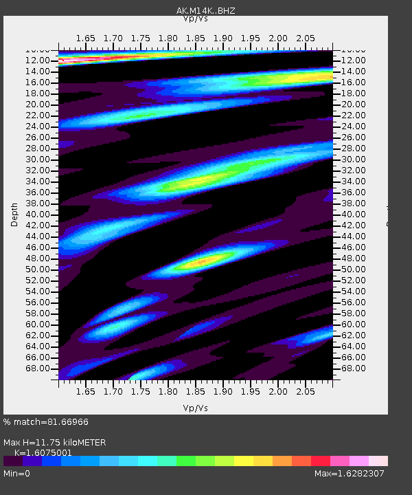
| Estimated Moho Depth: |
11.75 km |
| Estimated Crust Vp/Vs: |
1.61 |
| Assumed Crust Vp: |
6.182 km/s |
| Estimated Crust Vs: |
3.846 km/s |
| Estimated Crust Poisson's Ratio: |
0.18 |
|
| Radial Match: |
81.66966 % |
| Radial Bump: |
400 |
| Transverse Match: |
65.42549 % |
| Transverse Bump: |
400 |
| SOD ConfigId: |
29823551 |
| Insert Time: |
2022-12-18 19:44:59.803 +0000 |
| GWidth: |
2.5 |
| Max Bumps: |
400 |
| Tol: |
0.001 |
|

Signal To Noise
| Channel | StoN | STA | LTA |
| AK:M14K: :BHZ:20221204T19:35:30.539978Z | 3.5267515 | 6.3698476E-6 | 1.8061515E-6 |
| AK:M14K: :BHN:20221204T19:35:30.539978Z | 1.5377861 | 2.9121388E-6 | 1.8937216E-6 |
| AK:M14K: :BHE:20221204T19:35:30.539978Z | 1.2461728 | 3.7450418E-6 | 3.005235E-6 |
| Arrivals |
| Ps | 1.2 SECOND |
| PpPs | 4.8 SECOND |
| PsPs/PpSs | 6.0 SECOND |


