You are here: Home > Network List > IC - New China Digital Seismograph Network Stations List
> Station KMI Kunming, Yunnan Province, China > Earthquake Result Viewer
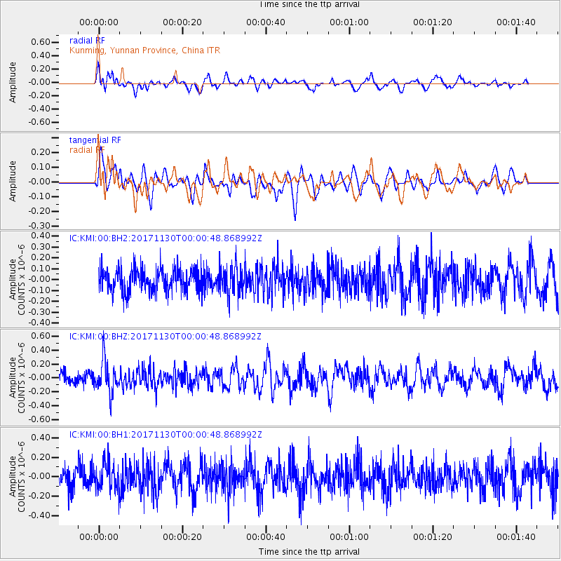
KMI Kunming, Yunnan Province, China - Earthquake Result Viewer
*The percent match for this event was below the threshold and hence no stack was calculated.
| Earthquake location: |
Banda Sea |
| Earthquake latitude/longitude: |
-6.8/129.8 |
| Earthquake time(UTC): |
2017/11/29 (333) 23:53:50 GMT |
| Earthquake Depth: |
160 km |
| Earthquake Magnitude: |
5.5 Mww |
| Earthquake Catalog/Contributor: |
NEIC PDE/us |
|
| Network: |
IC New China Digital Seismograph Network |
| Station: |
KMI Kunming, Yunnan Province, China |
| Lat/Lon: |
25.12 N/102.74 E |
| Elevation: |
1975 m |
|
| Distance: |
41.2 deg |
| Az: |
321.271 deg |
| Baz: |
136.73 deg |
| Ray Param: |
$rayparam |
*The percent match for this event was below the threshold and hence was not used in the summary stack. |
|
| Radial Match: |
57.97902 % |
| Radial Bump: |
400 |
| Transverse Match: |
55.675385 % |
| Transverse Bump: |
400 |
| SOD ConfigId: |
2973751 |
| Insert Time: |
2018-10-09 03:18:37.031 +0000 |
| GWidth: |
2.5 |
| Max Bumps: |
400 |
| Tol: |
0.001 |
|
Signal To Noise
| Channel | StoN | STA | LTA |
| IC:KMI:00:BHZ:20171130T00:00:48.868992Z | 2.693525 | 2.4011214E-7 | 8.9144194E-8 |
| IC:KMI:00:BH1:20171130T00:00:48.868992Z | 1.3385425 | 1.4789899E-7 | 1.10492564E-7 |
| IC:KMI:00:BH2:20171130T00:00:48.868992Z | 1.2692565 | 1.3324473E-7 | 1.0497857E-7 |
| Arrivals |
| Ps | |
| PpPs | |
| PsPs/PpSs | |


