You are here: Home > Network List > AT - Alaska Tsunami Warning Seismic System Stations List
> Station SIT Sitka, Alaska > Earthquake Result Viewer
SIT Sitka, Alaska - Earthquake Result Viewer
| Earthquake location: |
Samoa Islands Region |
| Earthquake latitude/longitude: |
-15.7/-172.5 |
| Earthquake time(UTC): |
2022/12/04 (338) 19:24:27 GMT |
| Earthquake Depth: |
148 km |
| Earthquake Magnitude: |
6.9 Mi |
| Earthquake Catalog/Contributor: |
NEIC PDE/at |
|
| Network: |
AT Alaska Tsunami Warning Seismic System |
| Station: |
SIT Sitka, Alaska |
| Lat/Lon: |
57.06 N/135.32 W |
| Elevation: |
19 m |
|
| Distance: |
78.8 deg |
| Az: |
19.667 deg |
| Baz: |
216.39 deg |
| Ray Param: |
0.04903903 |
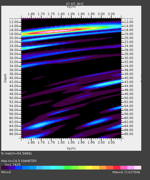
| Estimated Moho Depth: |
16.5 km |
| Estimated Crust Vp/Vs: |
1.76 |
| Assumed Crust Vp: |
6.472 km/s |
| Estimated Crust Vs: |
3.672 km/s |
| Estimated Crust Poisson's Ratio: |
0.26 |
|
| Radial Match: |
94.56961 % |
| Radial Bump: |
361 |
| Transverse Match: |
84.5706 % |
| Transverse Bump: |
400 |
| SOD ConfigId: |
29823551 |
| Insert Time: |
2022-12-18 19:47:21.982 +0000 |
| GWidth: |
2.5 |
| Max Bumps: |
400 |
| Tol: |
0.001 |
|

Signal To Noise
| Channel | StoN | STA | LTA |
| AT:SIT: :BHZ:20221204T19:35:42.400024Z | 14.212793 | 3.4795933E-6 | 2.448212E-7 |
| AT:SIT: :BHN:20221204T19:35:42.400024Z | 4.179993 | 8.5023595E-7 | 2.0340607E-7 |
| AT:SIT: :BHE:20221204T19:35:42.400024Z | 4.49367 | 1.1276202E-6 | 2.5093524E-7 |
| Arrivals |
| Ps | 2.0 SECOND |
| PpPs | 6.8 SECOND |
| PsPs/PpSs | 8.8 SECOND |


