You are here: Home > Network List > AU - Australian Seismological Centre Stations List
> Station KIM07 GSWA station > Earthquake Result Viewer
KIM07 GSWA station - Earthquake Result Viewer
| Earthquake location: |
Samoa Islands Region |
| Earthquake latitude/longitude: |
-15.7/-172.5 |
| Earthquake time(UTC): |
2022/12/04 (338) 19:24:27 GMT |
| Earthquake Depth: |
148 km |
| Earthquake Magnitude: |
6.9 Mi |
| Earthquake Catalog/Contributor: |
NEIC PDE/at |
|
| Network: |
AU Australian Seismological Centre |
| Station: |
KIM07 GSWA station |
| Lat/Lon: |
17.99 S/123.16 E |
| Elevation: |
101 m |
|
| Distance: |
61.3 deg |
| Az: |
257.839 deg |
| Baz: |
98.38 deg |
| Ray Param: |
0.06050265 |
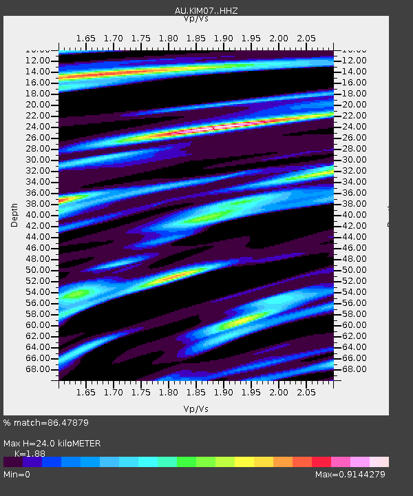
| Estimated Moho Depth: |
24.0 km |
| Estimated Crust Vp/Vs: |
1.88 |
| Assumed Crust Vp: |
6.159 km/s |
| Estimated Crust Vs: |
3.276 km/s |
| Estimated Crust Poisson's Ratio: |
0.30 |
|
| Radial Match: |
86.47879 % |
| Radial Bump: |
368 |
| Transverse Match: |
75.19978 % |
| Transverse Bump: |
400 |
| SOD ConfigId: |
29823551 |
| Insert Time: |
2022-12-18 19:48:18.966 +0000 |
| GWidth: |
2.5 |
| Max Bumps: |
400 |
| Tol: |
0.001 |
|

Signal To Noise
| Channel | StoN | STA | LTA |
| AU:KIM07: :HHZ:20221204T19:33:56.369995Z | 11.080658 | 2.7001283E-6 | 2.436794E-7 |
| AU:KIM07: :HHN:20221204T19:33:56.369995Z | 1.2171323 | 6.76174E-7 | 5.5554676E-7 |
| AU:KIM07: :HHE:20221204T19:33:56.369995Z | 2.429202 | 1.1971349E-6 | 4.9281E-7 |
| Arrivals |
| Ps | 3.6 SECOND |
| PpPs | 11 SECOND |
| PsPs/PpSs | 14 SECOND |


