You are here: Home > Network List > AU - Australian Seismological Centre Stations List
> Station PSAA1 Pilbara Seismic Array Element A1 > Earthquake Result Viewer
PSAA1 Pilbara Seismic Array Element A1 - Earthquake Result Viewer
| Earthquake location: |
Samoa Islands Region |
| Earthquake latitude/longitude: |
-15.7/-172.5 |
| Earthquake time(UTC): |
2022/12/04 (338) 19:24:27 GMT |
| Earthquake Depth: |
148 km |
| Earthquake Magnitude: |
6.9 Mi |
| Earthquake Catalog/Contributor: |
NEIC PDE/at |
|
| Network: |
AU Australian Seismological Centre |
| Station: |
PSAA1 Pilbara Seismic Array Element A1 |
| Lat/Lon: |
21.58 S/119.84 E |
| Elevation: |
325 m |
|
| Distance: |
64.0 deg |
| Az: |
253.378 deg |
| Baz: |
97.448 deg |
| Ray Param: |
0.058813903 |
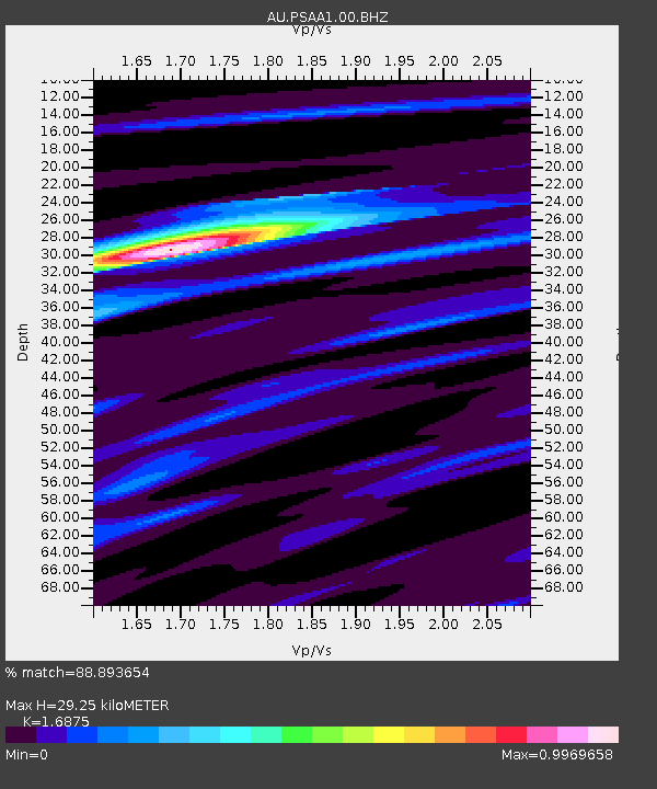
| Estimated Moho Depth: |
29.25 km |
| Estimated Crust Vp/Vs: |
1.69 |
| Assumed Crust Vp: |
6.464 km/s |
| Estimated Crust Vs: |
3.83 km/s |
| Estimated Crust Poisson's Ratio: |
0.23 |
|
| Radial Match: |
88.893654 % |
| Radial Bump: |
400 |
| Transverse Match: |
81.15128 % |
| Transverse Bump: |
400 |
| SOD ConfigId: |
29823551 |
| Insert Time: |
2022-12-18 19:48:57.351 +0000 |
| GWidth: |
2.5 |
| Max Bumps: |
400 |
| Tol: |
0.001 |
|

Signal To Noise
| Channel | StoN | STA | LTA |
| AU:PSAA1:00:BHZ:20221204T19:34:13.619019Z | 14.30763 | 2.496201E-6 | 1.7446644E-7 |
| AU:PSAA1:00:BH1:20221204T19:34:13.619019Z | 0.92457044 | 4.818373E-7 | 5.2114723E-7 |
| AU:PSAA1:00:BH2:20221204T19:34:13.619019Z | 7.979388 | 1.2292537E-6 | 1.5405362E-7 |
| Arrivals |
| Ps | 3.3 SECOND |
| PpPs | 12 SECOND |
| PsPs/PpSs | 15 SECOND |


