You are here: Home > Network List > AV - Alaska Volcano Observatory Stations List
> Station ANPB Aniakchak Pleny Bear, Alaska > Earthquake Result Viewer
ANPB Aniakchak Pleny Bear, Alaska - Earthquake Result Viewer
| Earthquake location: |
Samoa Islands Region |
| Earthquake latitude/longitude: |
-15.7/-172.5 |
| Earthquake time(UTC): |
2022/12/04 (338) 19:24:27 GMT |
| Earthquake Depth: |
148 km |
| Earthquake Magnitude: |
6.9 Mi |
| Earthquake Catalog/Contributor: |
NEIC PDE/at |
|
| Network: |
AV Alaska Volcano Observatory |
| Station: |
ANPB Aniakchak Pleny Bear, Alaska |
| Lat/Lon: |
56.80 N/158.28 W |
| Elevation: |
662 m |
|
| Distance: |
73.2 deg |
| Az: |
8.113 deg |
| Baz: |
194.306 deg |
| Ray Param: |
0.052788965 |
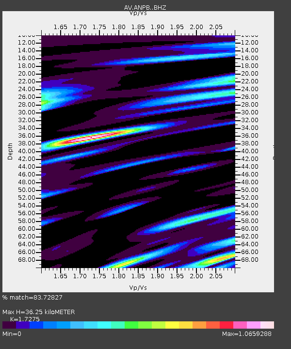
| Estimated Moho Depth: |
36.25 km |
| Estimated Crust Vp/Vs: |
1.73 |
| Assumed Crust Vp: |
6.134 km/s |
| Estimated Crust Vs: |
3.551 km/s |
| Estimated Crust Poisson's Ratio: |
0.25 |
|
| Radial Match: |
83.72827 % |
| Radial Bump: |
400 |
| Transverse Match: |
63.29318 % |
| Transverse Bump: |
400 |
| SOD ConfigId: |
29823551 |
| Insert Time: |
2022-12-18 19:49:53.579 +0000 |
| GWidth: |
2.5 |
| Max Bumps: |
400 |
| Tol: |
0.001 |
|
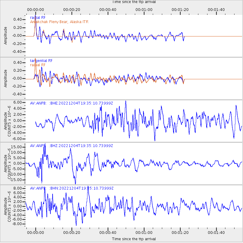
Signal To Noise
| Channel | StoN | STA | LTA |
| AV:ANPB: :BHZ:20221204T19:35:10.73999Z | 10.54791 | 7.239338E-6 | 6.8632914E-7 |
| AV:ANPB: :BHN:20221204T19:35:10.73999Z | 1.7696072 | 2.5103689E-6 | 1.4186023E-6 |
| AV:ANPB: :BHE:20221204T19:35:10.73999Z | 1.5346179 | 1.719161E-6 | 1.1202535E-6 |
| Arrivals |
| Ps | 4.4 SECOND |
| PpPs | 16 SECOND |
| PsPs/PpSs | 20 SECOND |


