You are here: Home > Network List > XA95 - Missouri to Massachusetts Transect Stations List
> Station MM13 Spiceland, Indiana > Earthquake Result Viewer
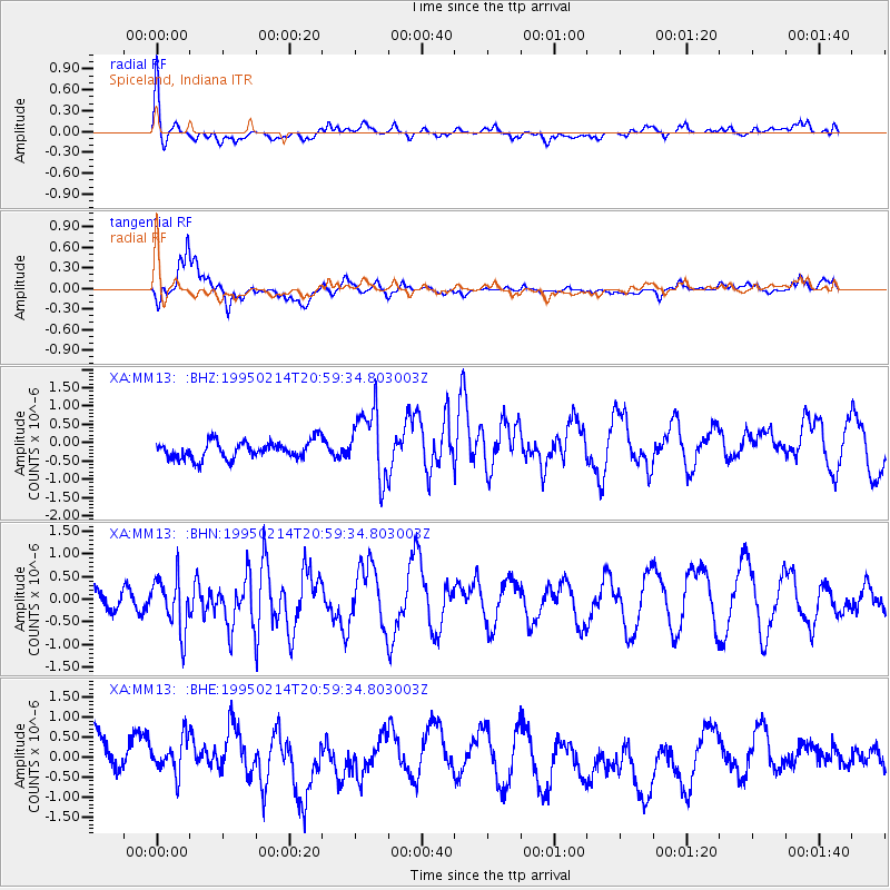
MM13 Spiceland, Indiana - Earthquake Result Viewer
*The percent match for this event was below the threshold and hence no stack was calculated.
| Earthquake location: |
East Of Kuril Islands |
| Earthquake latitude/longitude: |
44.0/148.1 |
| Earthquake time(UTC): |
1995/02/14 (045) 20:47:41 GMT |
| Earthquake Depth: |
37 km |
| Earthquake Magnitude: |
5.9 MB, 5.6 MS, 5.9 UNKNOWN, 5.9 MW |
| Earthquake Catalog/Contributor: |
WHDF/NEIC |
|
| Network: |
XA Missouri to Massachusetts Transect |
| Station: |
MM13 Spiceland, Indiana |
| Lat/Lon: |
39.83 N/85.31 W |
| Elevation: |
337 m |
|
| Distance: |
83.7 deg |
| Az: |
38.467 deg |
| Baz: |
324.333 deg |
| Ray Param: |
$rayparam |
*The percent match for this event was below the threshold and hence was not used in the summary stack. |
|
| Radial Match: |
60.62056 % |
| Radial Bump: |
390 |
| Transverse Match: |
70.66519 % |
| Transverse Bump: |
400 |
| SOD ConfigId: |
4480 |
| Insert Time: |
2010-02-26 17:53:26.970 +0000 |
| GWidth: |
2.5 |
| Max Bumps: |
400 |
| Tol: |
0.001 |
|
Signal To Noise
| Channel | StoN | STA | LTA |
| XA:MM13: :BHN:19950214T20:59:34.803003Z | 2.464569 | 6.018183E-7 | 2.4418802E-7 |
| XA:MM13: :BHE:19950214T20:59:34.803003Z | 1.0965922 | 6.062119E-7 | 5.5281436E-7 |
| XA:MM13: :BHZ:19950214T20:59:34.803003Z | 3.9314368 | 9.4069657E-7 | 2.3927552E-7 |
| Arrivals |
| Ps | |
| PpPs | |
| PsPs/PpSs | |


