You are here: Home > Network List > US - United States National Seismic Network Stations List
> Station AGMN Agassiz National Wildlife Refuge, Minnesota, USA > Earthquake Result Viewer
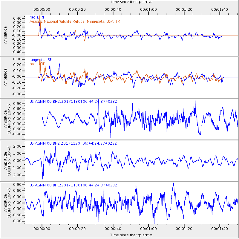
AGMN Agassiz National Wildlife Refuge, Minnesota, USA - Earthquake Result Viewer
*The percent match for this event was below the threshold and hence no stack was calculated.
| Earthquake location: |
Central Mid-Atlantic Ridge |
| Earthquake latitude/longitude: |
-1.1/-23.5 |
| Earthquake time(UTC): |
2017/11/30 (334) 06:32:52 GMT |
| Earthquake Depth: |
10 km |
| Earthquake Magnitude: |
6.5 Mi |
| Earthquake Catalog/Contributor: |
NEIC PDE/at |
|
| Network: |
US United States National Seismic Network |
| Station: |
AGMN Agassiz National Wildlife Refuge, Minnesota, USA |
| Lat/Lon: |
48.30 N/95.86 W |
| Elevation: |
351 m |
|
| Distance: |
79.2 deg |
| Az: |
319.615 deg |
| Baz: |
104.039 deg |
| Ray Param: |
$rayparam |
*The percent match for this event was below the threshold and hence was not used in the summary stack. |
|
| Radial Match: |
59.82165 % |
| Radial Bump: |
400 |
| Transverse Match: |
56.370274 % |
| Transverse Bump: |
400 |
| SOD ConfigId: |
2973751 |
| Insert Time: |
2018-10-09 03:23:01.597 +0000 |
| GWidth: |
2.5 |
| Max Bumps: |
400 |
| Tol: |
0.001 |
|
Signal To Noise
| Channel | StoN | STA | LTA |
| US:AGMN:00:BHZ:20171130T06:44:24.374023Z | 3.316032 | 9.502318E-7 | 2.865569E-7 |
| US:AGMN:00:BH1:20171130T06:44:24.374023Z | 1.232126 | 4.0111496E-7 | 3.2554703E-7 |
| US:AGMN:00:BH2:20171130T06:44:24.374023Z | 2.0865083 | 4.7525376E-7 | 2.2777466E-7 |
| Arrivals |
| Ps | |
| PpPs | |
| PsPs/PpSs | |


