You are here: Home > Network List > AV - Alaska Volcano Observatory Stations List
> Station SPNN North Nagishlamina, Mount Spurr, Alaska > Earthquake Result Viewer
SPNN North Nagishlamina, Mount Spurr, Alaska - Earthquake Result Viewer
| Earthquake location: |
Samoa Islands Region |
| Earthquake latitude/longitude: |
-15.7/-172.5 |
| Earthquake time(UTC): |
2022/12/04 (338) 19:24:27 GMT |
| Earthquake Depth: |
148 km |
| Earthquake Magnitude: |
6.9 Mi |
| Earthquake Catalog/Contributor: |
NEIC PDE/at |
|
| Network: |
AV Alaska Volcano Observatory |
| Station: |
SPNN North Nagishlamina, Mount Spurr, Alaska |
| Lat/Lon: |
61.37 N/152.70 W |
| Elevation: |
1666 m |
|
| Distance: |
78.4 deg |
| Az: |
9.587 deg |
| Baz: |
199.453 deg |
| Ray Param: |
0.049303107 |
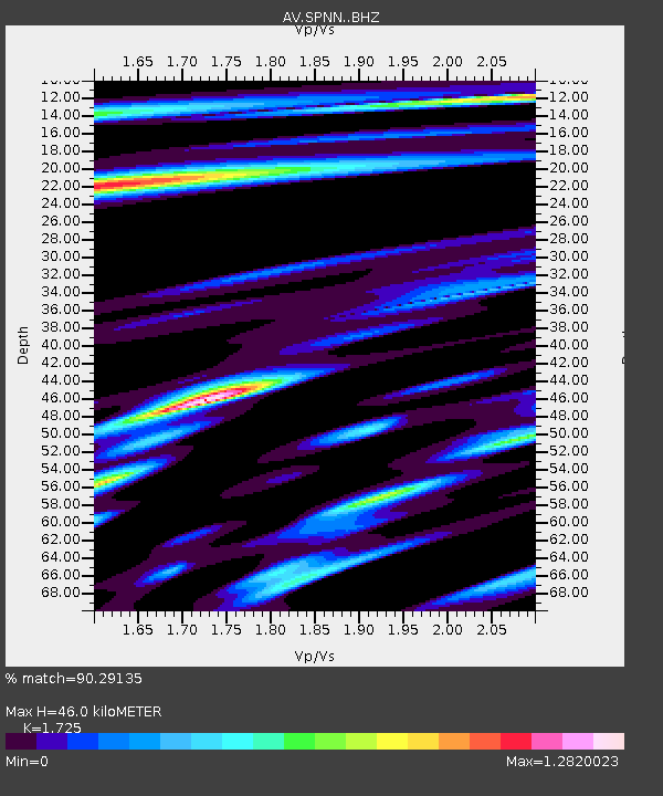
| Estimated Moho Depth: |
46.0 km |
| Estimated Crust Vp/Vs: |
1.73 |
| Assumed Crust Vp: |
6.566 km/s |
| Estimated Crust Vs: |
3.806 km/s |
| Estimated Crust Poisson's Ratio: |
0.25 |
|
| Radial Match: |
90.29135 % |
| Radial Bump: |
400 |
| Transverse Match: |
82.42062 % |
| Transverse Bump: |
400 |
| SOD ConfigId: |
29823551 |
| Insert Time: |
2022-12-18 19:53:34.812 +0000 |
| GWidth: |
2.5 |
| Max Bumps: |
400 |
| Tol: |
0.001 |
|

Signal To Noise
| Channel | StoN | STA | LTA |
| AV:SPNN: :BHZ:20221204T19:35:40.23999Z | 10.78046 | 4.3332534E-6 | 4.0195442E-7 |
| AV:SPNN: :BHN:20221204T19:35:40.23999Z | 5.3716054 | 1.4723413E-6 | 2.740971E-7 |
| AV:SPNN: :BHE:20221204T19:35:40.23999Z | 2.5483809 | 8.189024E-7 | 3.213422E-7 |
| Arrivals |
| Ps | 5.2 SECOND |
| PpPs | 18 SECOND |
| PsPs/PpSs | 24 SECOND |


