You are here: Home > Network List > TA - USArray Transportable Network (new EarthScope stations) Stations List
> Station 631A Perdido Creek Ranch, Del Rio, TX, USA > Earthquake Result Viewer
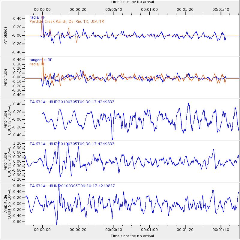
631A Perdido Creek Ranch, Del Rio, TX, USA - Earthquake Result Viewer
*The percent match for this event was below the threshold and hence no stack was calculated.
| Earthquake location: |
Near Coast Of Central Chile |
| Earthquake latitude/longitude: |
-36.6/-73.2 |
| Earthquake time(UTC): |
2010/03/05 (064) 09:19:36 GMT |
| Earthquake Depth: |
30 km |
| Earthquake Magnitude: |
5.9 MB, 5.8 MS, 6.1 MW, 6.0 MW |
| Earthquake Catalog/Contributor: |
WHDF/NEIC |
|
| Network: |
TA USArray Transportable Network (new EarthScope stations) |
| Station: |
631A Perdido Creek Ranch, Del Rio, TX, USA |
| Lat/Lon: |
29.41 N/100.58 W |
| Elevation: |
344 m |
|
| Distance: |
70.5 deg |
| Az: |
334.838 deg |
| Baz: |
156.922 deg |
| Ray Param: |
$rayparam |
*The percent match for this event was below the threshold and hence was not used in the summary stack. |
|
| Radial Match: |
59.79738 % |
| Radial Bump: |
400 |
| Transverse Match: |
65.7842 % |
| Transverse Bump: |
400 |
| SOD ConfigId: |
299721 |
| Insert Time: |
2010-04-26 16:49:58.960 +0000 |
| GWidth: |
2.5 |
| Max Bumps: |
400 |
| Tol: |
0.001 |
|
Signal To Noise
| Channel | StoN | STA | LTA |
| TA:631A: :BHZ:20100305T09:30:17.424983Z | 1.5655636 | 4.2228652E-7 | 2.697345E-7 |
| TA:631A: :BHN:20100305T09:30:17.424983Z | 0.6560192 | 1.14399526E-7 | 1.7438443E-7 |
| TA:631A: :BHE:20100305T09:30:17.424983Z | 0.8852938 | 1.2461771E-7 | 1.4076424E-7 |
| Arrivals |
| Ps | |
| PpPs | |
| PsPs/PpSs | |


