You are here: Home > Network List > C0 - Colorado Geological Survey Seismic Network Stations List
> Station SPVA SPVA > Earthquake Result Viewer
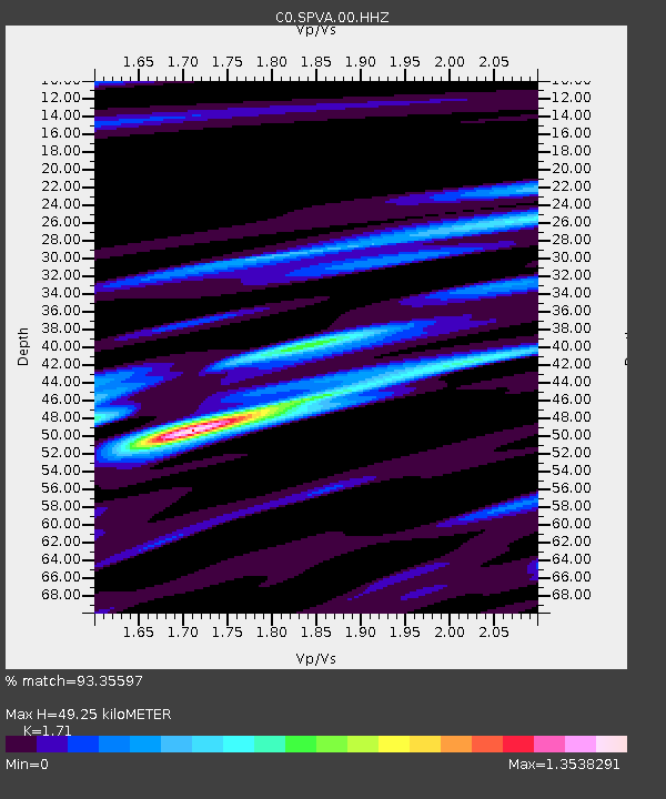
SPVA SPVA - Earthquake Result Viewer
| Earthquake location: |
Samoa Islands Region |
| Earthquake latitude/longitude: |
-15.7/-172.5 |
| Earthquake time(UTC): |
2022/12/04 (338) 19:24:27 GMT |
| Earthquake Depth: |
148 km |
| Earthquake Magnitude: |
6.9 Mi |
| Earthquake Catalog/Contributor: |
NEIC PDE/at |
|
| Network: |
C0 Colorado Geological Survey Seismic Network |
| Station: |
SPVA SPVA |
| Lat/Lon: |
39.47 N/107.22 W |
| Elevation: |
2176 m |
|
| Distance: |
81.9 deg |
| Az: |
45.253 deg |
| Baz: |
242.101 deg |
| Ray Param: |
0.046943203 |
| Estimated Moho Depth: |
49.25 km |
| Estimated Crust Vp/Vs: |
1.71 |
| Assumed Crust Vp: |
6.306 km/s |
| Estimated Crust Vs: |
3.688 km/s |
| Estimated Crust Poisson's Ratio: |
0.24 |
|
| Radial Match: |
93.35597 % |
| Radial Bump: |
396 |
| Transverse Match: |
88.9802 % |
| Transverse Bump: |
400 |
| SOD ConfigId: |
29823551 |
| Insert Time: |
2022-12-18 19:56:05.537 +0000 |
| GWidth: |
2.5 |
| Max Bumps: |
400 |
| Tol: |
0.001 |
|

Signal To Noise
| Channel | StoN | STA | LTA |
| C0:SPVA:00:HHZ:20221204T19:35:58.655029Z | 6.235482 | 1.1551799E-6 | 1.8525911E-7 |
| C0:SPVA:00:HHN:20221204T19:35:58.655029Z | 1.3341695 | 1.4480358E-7 | 1.0853462E-7 |
| C0:SPVA:00:HHE:20221204T19:35:58.655029Z | 2.4957042 | 3.8722658E-7 | 1.5515724E-7 |
| Arrivals |
| Ps | 5.7 SECOND |
| PpPs | 21 SECOND |
| PsPs/PpSs | 26 SECOND |


