You are here: Home > Network List > CC - Cascade Chain Volcano Monitoring Stations List
> Station PALM Top of Palmer Lift > Earthquake Result Viewer
PALM Top of Palmer Lift - Earthquake Result Viewer
| Earthquake location: |
Samoa Islands Region |
| Earthquake latitude/longitude: |
-15.7/-172.5 |
| Earthquake time(UTC): |
2022/12/04 (338) 19:24:27 GMT |
| Earthquake Depth: |
148 km |
| Earthquake Magnitude: |
6.9 Mi |
| Earthquake Catalog/Contributor: |
NEIC PDE/at |
|
| Network: |
CC Cascade Chain Volcano Monitoring |
| Station: |
PALM Top of Palmer Lift |
| Lat/Lon: |
45.36 N/121.71 W |
| Elevation: |
2590 m |
|
| Distance: |
76.2 deg |
| Az: |
34.234 deg |
| Baz: |
230.222 deg |
| Ray Param: |
0.05079303 |
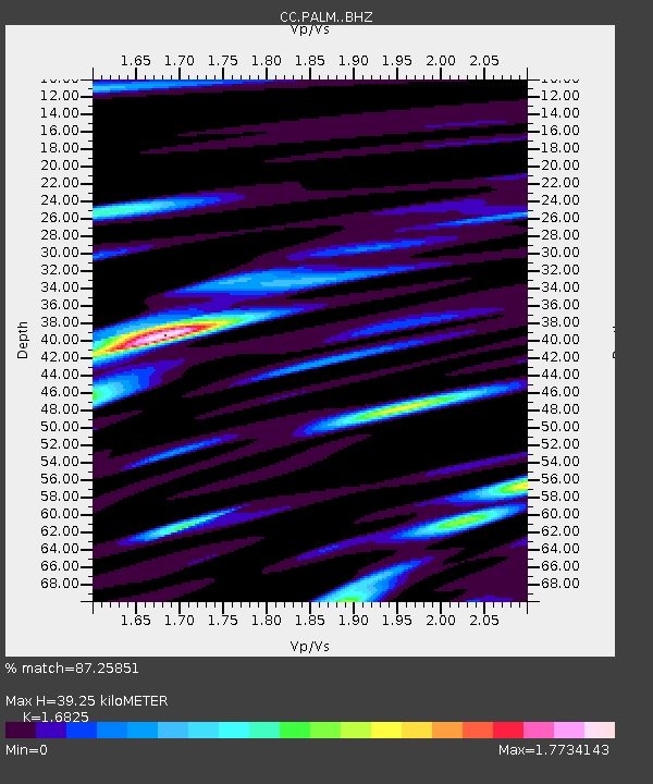
| Estimated Moho Depth: |
39.25 km |
| Estimated Crust Vp/Vs: |
1.68 |
| Assumed Crust Vp: |
6.597 km/s |
| Estimated Crust Vs: |
3.921 km/s |
| Estimated Crust Poisson's Ratio: |
0.23 |
|
| Radial Match: |
87.25851 % |
| Radial Bump: |
400 |
| Transverse Match: |
89.9583 % |
| Transverse Bump: |
400 |
| SOD ConfigId: |
29823551 |
| Insert Time: |
2022-12-18 19:57:29.067 +0000 |
| GWidth: |
2.5 |
| Max Bumps: |
400 |
| Tol: |
0.001 |
|

Signal To Noise
| Channel | StoN | STA | LTA |
| CC:PALM: :BHZ:20221204T19:35:27.960022Z | 10.72954 | 3.661759E-6 | 3.4127828E-7 |
| CC:PALM: :BHN:20221204T19:35:27.960022Z | 2.6035852 | 1.7195102E-6 | 6.604394E-7 |
| CC:PALM: :BHE:20221204T19:35:27.960022Z | 1.5860189 | 9.1853195E-7 | 5.7914315E-7 |
| Arrivals |
| Ps | 4.2 SECOND |
| PpPs | 15 SECOND |
| PsPs/PpSs | 20 SECOND |


