You are here: Home > Network List > CC - Cascade Chain Volcano Monitoring Stations List
> Station UNFR Upper North Fork Repeater > Earthquake Result Viewer
UNFR Upper North Fork Repeater - Earthquake Result Viewer
| Earthquake location: |
Samoa Islands Region |
| Earthquake latitude/longitude: |
-15.7/-172.5 |
| Earthquake time(UTC): |
2022/12/04 (338) 19:24:27 GMT |
| Earthquake Depth: |
148 km |
| Earthquake Magnitude: |
6.9 Mi |
| Earthquake Catalog/Contributor: |
NEIC PDE/at |
|
| Network: |
CC Cascade Chain Volcano Monitoring |
| Station: |
UNFR Upper North Fork Repeater |
| Lat/Lon: |
46.27 N/122.29 W |
| Elevation: |
884 m |
|
| Distance: |
76.5 deg |
| Az: |
33.243 deg |
| Baz: |
229.568 deg |
| Ray Param: |
0.050606545 |
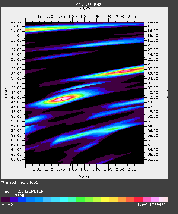
| Estimated Moho Depth: |
42.5 km |
| Estimated Crust Vp/Vs: |
1.75 |
| Assumed Crust Vp: |
6.566 km/s |
| Estimated Crust Vs: |
3.747 km/s |
| Estimated Crust Poisson's Ratio: |
0.26 |
|
| Radial Match: |
93.64606 % |
| Radial Bump: |
400 |
| Transverse Match: |
89.59038 % |
| Transverse Bump: |
400 |
| SOD ConfigId: |
29823551 |
| Insert Time: |
2022-12-18 19:58:13.252 +0000 |
| GWidth: |
2.5 |
| Max Bumps: |
400 |
| Tol: |
0.001 |
|

Signal To Noise
| Channel | StoN | STA | LTA |
| CC:UNFR: :BHZ:20221204T19:35:29.500Z | 18.927296 | 4.022162E-6 | 2.1250591E-7 |
| CC:UNFR: :BHN:20221204T19:35:29.500Z | 4.722174 | 1.1856441E-6 | 2.5108014E-7 |
| CC:UNFR: :BHE:20221204T19:35:29.500Z | 4.392268 | 1.186862E-6 | 2.7021622E-7 |
| Arrivals |
| Ps | 5.0 SECOND |
| PpPs | 17 SECOND |
| PsPs/PpSs | 22 SECOND |


