You are here: Home > Network List > XA95 - Missouri to Massachusetts Transect Stations List
> Station MM13 Spiceland, Indiana > Earthquake Result Viewer
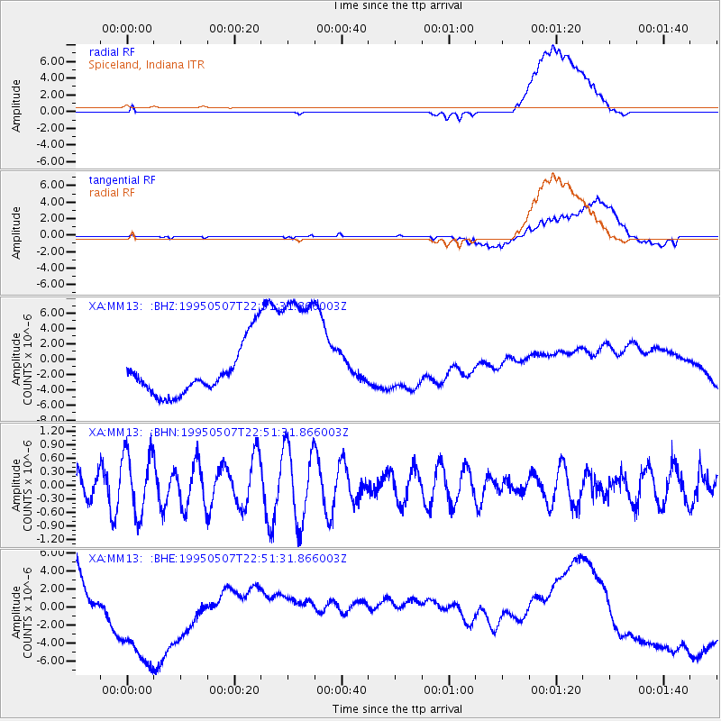
MM13 Spiceland, Indiana - Earthquake Result Viewer
*The percent match for this event was below the threshold and hence no stack was calculated.
| Earthquake location: |
Tonga Islands |
| Earthquake latitude/longitude: |
-15.4/-173.4 |
| Earthquake time(UTC): |
1995/05/07 (127) 22:38:29 GMT |
| Earthquake Depth: |
33 km |
| Earthquake Magnitude: |
5.7 MS, 5.3 MB, 6.0 UNKNOWN, 5.9 MW |
| Earthquake Catalog/Contributor: |
WHDF/NEIC |
|
| Network: |
XA Missouri to Massachusetts Transect |
| Station: |
MM13 Spiceland, Indiana |
| Lat/Lon: |
39.83 N/85.31 W |
| Elevation: |
337 m |
|
| Distance: |
98.3 deg |
| Az: |
51.05 deg |
| Baz: |
256.968 deg |
| Ray Param: |
$rayparam |
*The percent match for this event was below the threshold and hence was not used in the summary stack. |
|
| Radial Match: |
27.313978 % |
| Radial Bump: |
400 |
| Transverse Match: |
17.643892 % |
| Transverse Bump: |
400 |
| SOD ConfigId: |
4480 |
| Insert Time: |
2010-02-26 17:53:28.546 +0000 |
| GWidth: |
2.5 |
| Max Bumps: |
400 |
| Tol: |
0.001 |
|
Signal To Noise
| Channel | StoN | STA | LTA |
| XA:MM13: :BHN:19950507T22:51:31.866003Z | 1.4545727 | 7.029937E-7 | 4.832991E-7 |
| XA:MM13: :BHE:19950507T22:51:31.866003Z | 3.983143 | 7.1032623E-6 | 1.783331E-6 |
| XA:MM13: :BHZ:19950507T22:51:31.866003Z | 2.9552605 | 9.123643E-6 | 3.0872552E-6 |
| Arrivals |
| Ps | |
| PpPs | |
| PsPs/PpSs | |


