You are here: Home > Network List > CI - Caltech Regional Seismic Network Stations List
> Station DAN Danby, California, USA > Earthquake Result Viewer
DAN Danby, California, USA - Earthquake Result Viewer
| Earthquake location: |
Samoa Islands Region |
| Earthquake latitude/longitude: |
-15.7/-172.5 |
| Earthquake time(UTC): |
2022/12/04 (338) 19:24:27 GMT |
| Earthquake Depth: |
148 km |
| Earthquake Magnitude: |
6.9 Mi |
| Earthquake Catalog/Contributor: |
NEIC PDE/at |
|
| Network: |
CI Caltech Regional Seismic Network |
| Station: |
DAN Danby, California, USA |
| Lat/Lon: |
34.64 N/115.38 W |
| Elevation: |
398 m |
|
| Distance: |
73.8 deg |
| Az: |
46.145 deg |
| Baz: |
237.385 deg |
| Ray Param: |
0.05239399 |
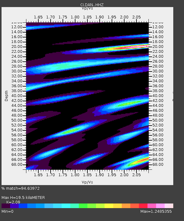
| Estimated Moho Depth: |
19.5 km |
| Estimated Crust Vp/Vs: |
2.09 |
| Assumed Crust Vp: |
6.276 km/s |
| Estimated Crust Vs: |
3.003 km/s |
| Estimated Crust Poisson's Ratio: |
0.35 |
|
| Radial Match: |
94.63972 % |
| Radial Bump: |
400 |
| Transverse Match: |
86.61773 % |
| Transverse Bump: |
400 |
| SOD ConfigId: |
29823551 |
| Insert Time: |
2022-12-18 19:58:55.432 +0000 |
| GWidth: |
2.5 |
| Max Bumps: |
400 |
| Tol: |
0.001 |
|
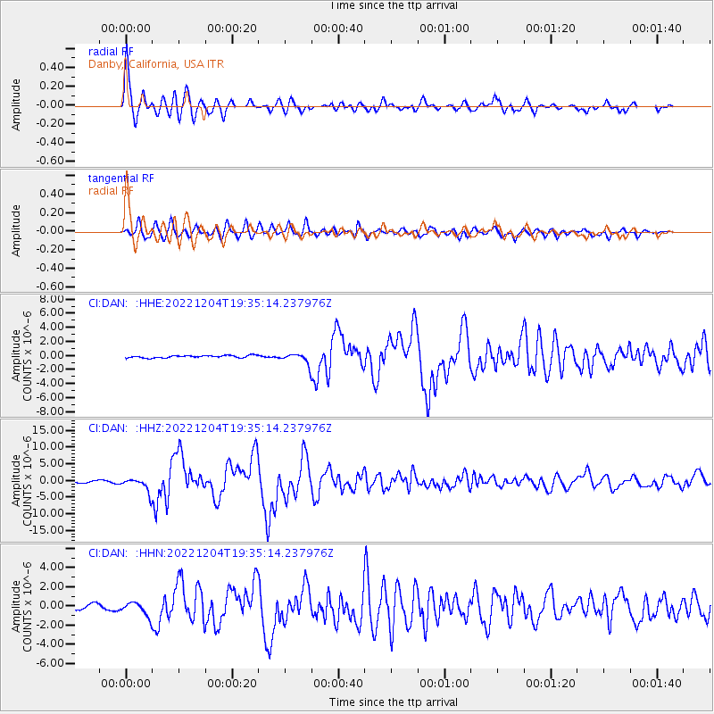
Signal To Noise
| Channel | StoN | STA | LTA |
| CI:DAN: :HHZ:20221204T19:35:14.237976Z | 6.443471 | 2.1282485E-6 | 3.3029536E-7 |
| CI:DAN: :HHN:20221204T19:35:14.237976Z | 2.7215853 | 7.039515E-7 | 2.5865495E-7 |
| CI:DAN: :HHE:20221204T19:35:14.237976Z | 4.5105696 | 7.5391887E-7 | 1.6714495E-7 |
| Arrivals |
| Ps | 3.5 SECOND |
| PpPs | 9.3 SECOND |
| PsPs/PpSs | 13 SECOND |


