You are here: Home > Network List > CI - Caltech Regional Seismic Network Stations List
> Station MPP McPhearson Peak > Earthquake Result Viewer
MPP McPhearson Peak - Earthquake Result Viewer
| Earthquake location: |
Samoa Islands Region |
| Earthquake latitude/longitude: |
-15.7/-172.5 |
| Earthquake time(UTC): |
2022/12/04 (338) 19:24:27 GMT |
| Earthquake Depth: |
148 km |
| Earthquake Magnitude: |
6.9 Mi |
| Earthquake Catalog/Contributor: |
NEIC PDE/at |
|
| Network: |
CI Caltech Regional Seismic Network |
| Station: |
MPP McPhearson Peak |
| Lat/Lon: |
34.89 N/119.81 W |
| Elevation: |
1739 m |
|
| Distance: |
70.9 deg |
| Az: |
43.773 deg |
| Baz: |
234.149 deg |
| Ray Param: |
0.054286987 |
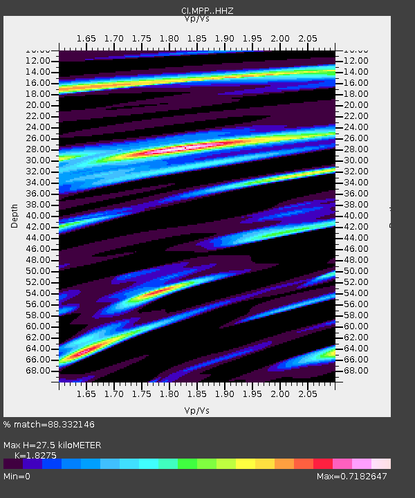
| Estimated Moho Depth: |
27.5 km |
| Estimated Crust Vp/Vs: |
1.83 |
| Assumed Crust Vp: |
6.1 km/s |
| Estimated Crust Vs: |
3.338 km/s |
| Estimated Crust Poisson's Ratio: |
0.29 |
|
| Radial Match: |
88.332146 % |
| Radial Bump: |
400 |
| Transverse Match: |
80.46434 % |
| Transverse Bump: |
400 |
| SOD ConfigId: |
29823551 |
| Insert Time: |
2022-12-18 19:59:45.025 +0000 |
| GWidth: |
2.5 |
| Max Bumps: |
400 |
| Tol: |
0.001 |
|
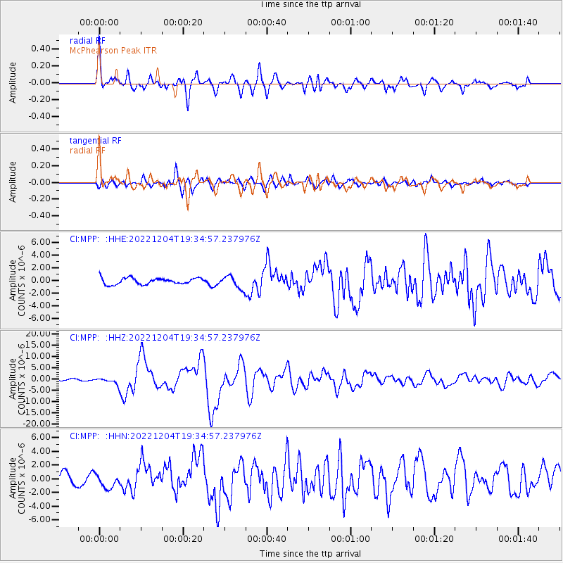
Signal To Noise
| Channel | StoN | STA | LTA |
| CI:MPP: :HHZ:20221204T19:34:57.237976Z | 6.2190986 | 1.473254E-6 | 2.3689188E-7 |
| CI:MPP: :HHN:20221204T19:34:57.237976Z | 0.98897576 | 1.0553539E-6 | 1.067118E-6 |
| CI:MPP: :HHE:20221204T19:34:57.237976Z | 2.103242 | 1.0375863E-6 | 4.9332715E-7 |
| Arrivals |
| Ps | 3.8 SECOND |
| PpPs | 12 SECOND |
| PsPs/PpSs | 16 SECOND |


