You are here: Home > Network List > CI - Caltech Regional Seismic Network Stations List
> Station OSI Osito Adit, California, USA > Earthquake Result Viewer
OSI Osito Adit, California, USA - Earthquake Result Viewer
| Earthquake location: |
Samoa Islands Region |
| Earthquake latitude/longitude: |
-15.7/-172.5 |
| Earthquake time(UTC): |
2022/12/04 (338) 19:24:27 GMT |
| Earthquake Depth: |
148 km |
| Earthquake Magnitude: |
6.9 Mi |
| Earthquake Catalog/Contributor: |
NEIC PDE/at |
|
| Network: |
CI Caltech Regional Seismic Network |
| Station: |
OSI Osito Adit, California, USA |
| Lat/Lon: |
34.61 N/118.72 W |
| Elevation: |
706 m |
|
| Distance: |
71.5 deg |
| Az: |
44.558 deg |
| Baz: |
235.021 deg |
| Ray Param: |
0.0539053 |
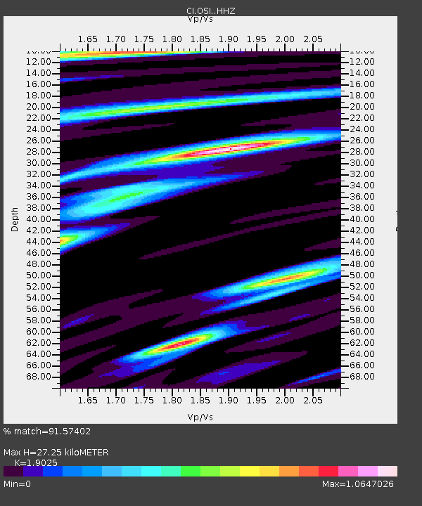
| Estimated Moho Depth: |
27.25 km |
| Estimated Crust Vp/Vs: |
1.90 |
| Assumed Crust Vp: |
6.1 km/s |
| Estimated Crust Vs: |
3.206 km/s |
| Estimated Crust Poisson's Ratio: |
0.31 |
|
| Radial Match: |
91.57402 % |
| Radial Bump: |
332 |
| Transverse Match: |
84.9138 % |
| Transverse Bump: |
400 |
| SOD ConfigId: |
29823551 |
| Insert Time: |
2022-12-18 19:59:55.670 +0000 |
| GWidth: |
2.5 |
| Max Bumps: |
400 |
| Tol: |
0.001 |
|
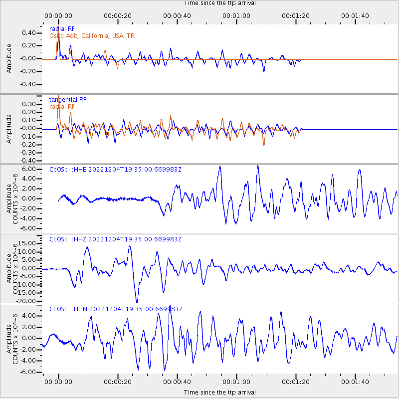
Signal To Noise
| Channel | StoN | STA | LTA |
| CI:OSI: :HHZ:20221204T19:35:00.669983Z | 10.619721 | 2.4731385E-6 | 2.3288166E-7 |
| CI:OSI: :HHN:20221204T19:35:00.669983Z | 1.0552566 | 5.392597E-7 | 5.1102234E-7 |
| CI:OSI: :HHE:20221204T19:35:00.669983Z | 1.930967 | 7.258134E-7 | 3.7588077E-7 |
| Arrivals |
| Ps | 4.2 SECOND |
| PpPs | 13 SECOND |
| PsPs/PpSs | 17 SECOND |


