You are here: Home > Network List > CI - Caltech Regional Seismic Network Stations List
> Station SWS Sam W. Stewart, Westmorland, CA, USA > Earthquake Result Viewer
SWS Sam W. Stewart, Westmorland, CA, USA - Earthquake Result Viewer
| Earthquake location: |
Samoa Islands Region |
| Earthquake latitude/longitude: |
-15.7/-172.5 |
| Earthquake time(UTC): |
2022/12/04 (338) 19:24:27 GMT |
| Earthquake Depth: |
148 km |
| Earthquake Magnitude: |
6.9 Mi |
| Earthquake Catalog/Contributor: |
NEIC PDE/at |
|
| Network: |
CI Caltech Regional Seismic Network |
| Station: |
SWS Sam W. Stewart, Westmorland, CA, USA |
| Lat/Lon: |
32.94 N/115.80 W |
| Elevation: |
140 m |
|
| Distance: |
72.6 deg |
| Az: |
47.44 deg |
| Baz: |
237.53 deg |
| Ray Param: |
0.05318137 |
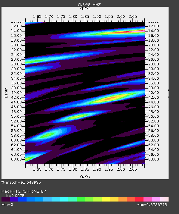
| Estimated Moho Depth: |
13.75 km |
| Estimated Crust Vp/Vs: |
2.10 |
| Assumed Crust Vp: |
6.155 km/s |
| Estimated Crust Vs: |
2.934 km/s |
| Estimated Crust Poisson's Ratio: |
0.35 |
|
| Radial Match: |
91.048935 % |
| Radial Bump: |
400 |
| Transverse Match: |
77.71677 % |
| Transverse Bump: |
400 |
| SOD ConfigId: |
29823551 |
| Insert Time: |
2022-12-18 20:00:34.647 +0000 |
| GWidth: |
2.5 |
| Max Bumps: |
400 |
| Tol: |
0.001 |
|
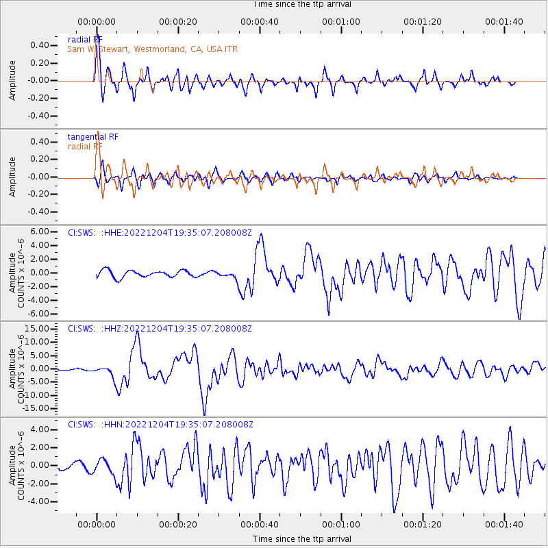
Signal To Noise
| Channel | StoN | STA | LTA |
| CI:SWS: :HHZ:20221204T19:35:07.208008Z | 4.9012504 | 2.2946454E-6 | 4.681755E-7 |
| CI:SWS: :HHN:20221204T19:35:07.208008Z | 2.6761048 | 8.5094644E-7 | 3.179795E-7 |
| CI:SWS: :HHE:20221204T19:35:07.208008Z | 1.1616133 | 5.885053E-7 | 5.066275E-7 |
| Arrivals |
| Ps | 2.5 SECOND |
| PpPs | 6.7 SECOND |
| PsPs/PpSs | 9.3 SECOND |


