You are here: Home > Network List > CI - Caltech Regional Seismic Network Stations List
> Station TUQ Turquiose Mountain, Baker, CA, USA > Earthquake Result Viewer
TUQ Turquiose Mountain, Baker, CA, USA - Earthquake Result Viewer
| Earthquake location: |
Samoa Islands Region |
| Earthquake latitude/longitude: |
-15.7/-172.5 |
| Earthquake time(UTC): |
2022/12/04 (338) 19:24:27 GMT |
| Earthquake Depth: |
148 km |
| Earthquake Magnitude: |
6.9 Mi |
| Earthquake Catalog/Contributor: |
NEIC PDE/at |
|
| Network: |
CI Caltech Regional Seismic Network |
| Station: |
TUQ Turquiose Mountain, Baker, CA, USA |
| Lat/Lon: |
35.44 N/115.92 W |
| Elevation: |
1350 m |
|
| Distance: |
73.9 deg |
| Az: |
45.196 deg |
| Baz: |
236.811 deg |
| Ray Param: |
0.052354313 |
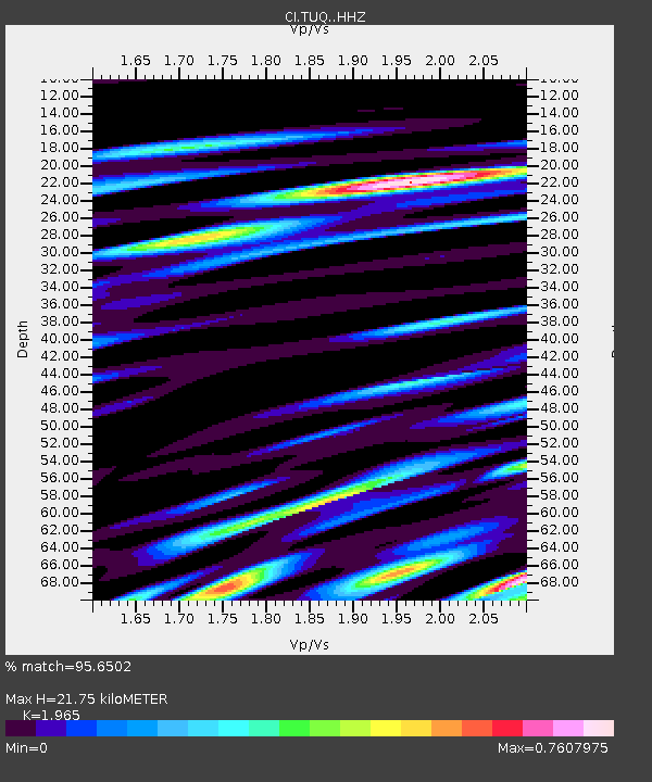
| Estimated Moho Depth: |
21.75 km |
| Estimated Crust Vp/Vs: |
1.97 |
| Assumed Crust Vp: |
6.276 km/s |
| Estimated Crust Vs: |
3.194 km/s |
| Estimated Crust Poisson's Ratio: |
0.33 |
|
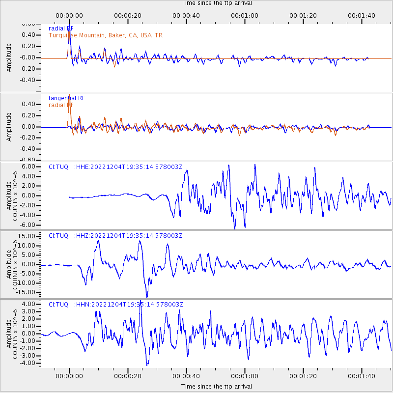
| Radial Match: |
95.6502 % |
| Radial Bump: |
400 |
| Transverse Match: |
89.35266 % |
| Transverse Bump: |
400 |
| SOD ConfigId: |
29823551 |
| Insert Time: |
2022-12-18 20:00:42.298 +0000 |
| GWidth: |
2.5 |
| Max Bumps: |
400 |
| Tol: |
0.001 |
|
Signal To Noise
| Channel | StoN | STA | LTA |
| CI:TUQ: :HHZ:20221204T19:35:14.578003Z | 14.922389 | 2.150451E-6 | 1.4410904E-7 |
| CI:TUQ: :HHN:20221204T19:35:14.578003Z | 4.5710807 | 5.588239E-7 | 1.2225203E-7 |
| CI:TUQ: :HHE:20221204T19:35:14.578003Z | 3.6182144 | 9.266386E-7 | 2.5610385E-7 |
| Arrivals |
| Ps | 3.4 SECOND |
| PpPs | 10.0 SECOND |
| PsPs/PpSs | 13 SECOND |


