You are here: Home > Network List > CN - Canadian National Seismograph Network Stations List
> Station MGRB Mount Grey, BC, CA > Earthquake Result Viewer
MGRB Mount Grey, BC, CA - Earthquake Result Viewer
| Earthquake location: |
Samoa Islands Region |
| Earthquake latitude/longitude: |
-15.7/-172.5 |
| Earthquake time(UTC): |
2022/12/04 (338) 19:24:27 GMT |
| Earthquake Depth: |
148 km |
| Earthquake Magnitude: |
6.9 Mi |
| Earthquake Catalog/Contributor: |
NEIC PDE/at |
|
| Network: |
CN Canadian National Seismograph Network |
| Station: |
MGRB Mount Grey, BC, CA |
| Lat/Lon: |
49.00 N/124.70 W |
| Elevation: |
1310 m |
|
| Distance: |
77.1 deg |
| Az: |
30.038 deg |
| Baz: |
227.063 deg |
| Ray Param: |
0.050213676 |
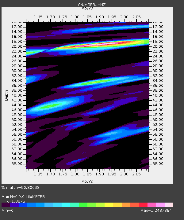
| Estimated Moho Depth: |
19.0 km |
| Estimated Crust Vp/Vs: |
1.89 |
| Assumed Crust Vp: |
6.391 km/s |
| Estimated Crust Vs: |
3.386 km/s |
| Estimated Crust Poisson's Ratio: |
0.30 |
|
| Radial Match: |
90.80038 % |
| Radial Bump: |
400 |
| Transverse Match: |
85.310005 % |
| Transverse Bump: |
400 |
| SOD ConfigId: |
29823551 |
| Insert Time: |
2022-12-18 20:01:51.297 +0000 |
| GWidth: |
2.5 |
| Max Bumps: |
400 |
| Tol: |
0.001 |
|

Signal To Noise
| Channel | StoN | STA | LTA |
| CN:MGRB: :HHZ:20221204T19:35:32.859985Z | 7.534961 | 3.7939615E-6 | 5.035144E-7 |
| CN:MGRB: :HHN:20221204T19:35:32.859985Z | 1.4931653 | 8.955303E-7 | 5.9975304E-7 |
| CN:MGRB: :HHE:20221204T19:35:32.859985Z | 2.5819535 | 1.44128E-6 | 5.58213E-7 |
| Arrivals |
| Ps | 2.7 SECOND |
| PpPs | 8.3 SECOND |
| PsPs/PpSs | 11 SECOND |


