You are here: Home > Network List > CN - Canadian National Seismograph Network Stations List
> Station PACB Port Alice, BC, CA > Earthquake Result Viewer
PACB Port Alice, BC, CA - Earthquake Result Viewer
| Earthquake location: |
Samoa Islands Region |
| Earthquake latitude/longitude: |
-15.7/-172.5 |
| Earthquake time(UTC): |
2022/12/04 (338) 19:24:27 GMT |
| Earthquake Depth: |
148 km |
| Earthquake Magnitude: |
6.9 Mi |
| Earthquake Catalog/Contributor: |
NEIC PDE/at |
|
| Network: |
CN Canadian National Seismograph Network |
| Station: |
PACB Port Alice, BC, CA |
| Lat/Lon: |
50.44 N/127.49 W |
| Elevation: |
24 m |
|
| Distance: |
76.8 deg |
| Az: |
27.682 deg |
| Baz: |
224.403 deg |
| Ray Param: |
0.050404143 |
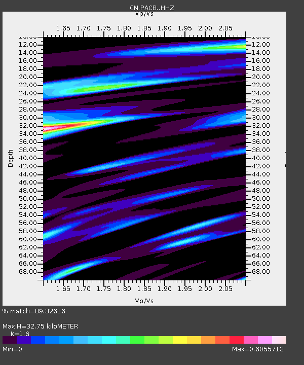
| Estimated Moho Depth: |
32.75 km |
| Estimated Crust Vp/Vs: |
1.60 |
| Assumed Crust Vp: |
6.545 km/s |
| Estimated Crust Vs: |
4.091 km/s |
| Estimated Crust Poisson's Ratio: |
0.18 |
|
| Radial Match: |
89.32616 % |
| Radial Bump: |
400 |
| Transverse Match: |
72.76217 % |
| Transverse Bump: |
400 |
| SOD ConfigId: |
29823551 |
| Insert Time: |
2022-12-18 20:02:06.266 +0000 |
| GWidth: |
2.5 |
| Max Bumps: |
400 |
| Tol: |
0.001 |
|

Signal To Noise
| Channel | StoN | STA | LTA |
| CN:PACB: :HHZ:20221204T19:35:31.200012Z | 6.522517 | 3.8721446E-6 | 5.9365806E-7 |
| CN:PACB: :HHN:20221204T19:35:31.200012Z | 2.9282653 | 1.6628885E-6 | 5.6787496E-7 |
| CN:PACB: :HHE:20221204T19:35:31.200012Z | 1.3170829 | 7.945772E-7 | 6.032856E-7 |
| Arrivals |
| Ps | 3.1 SECOND |
| PpPs | 13 SECOND |
| PsPs/PpSs | 16 SECOND |


