You are here: Home > Network List > CN - Canadian National Seismograph Network Stations List
> Station VGZ Victoria Gonzales, BC, CA > Earthquake Result Viewer
VGZ Victoria Gonzales, BC, CA - Earthquake Result Viewer
| Earthquake location: |
Samoa Islands Region |
| Earthquake latitude/longitude: |
-15.7/-172.5 |
| Earthquake time(UTC): |
2022/12/04 (338) 19:24:27 GMT |
| Earthquake Depth: |
148 km |
| Earthquake Magnitude: |
6.9 Mi |
| Earthquake Catalog/Contributor: |
NEIC PDE/at |
|
| Network: |
CN Canadian National Seismograph Network |
| Station: |
VGZ Victoria Gonzales, BC, CA |
| Lat/Lon: |
48.41 N/123.33 W |
| Elevation: |
67 m |
|
| Distance: |
77.4 deg |
| Az: |
31.111 deg |
| Baz: |
228.328 deg |
| Ray Param: |
0.050028186 |
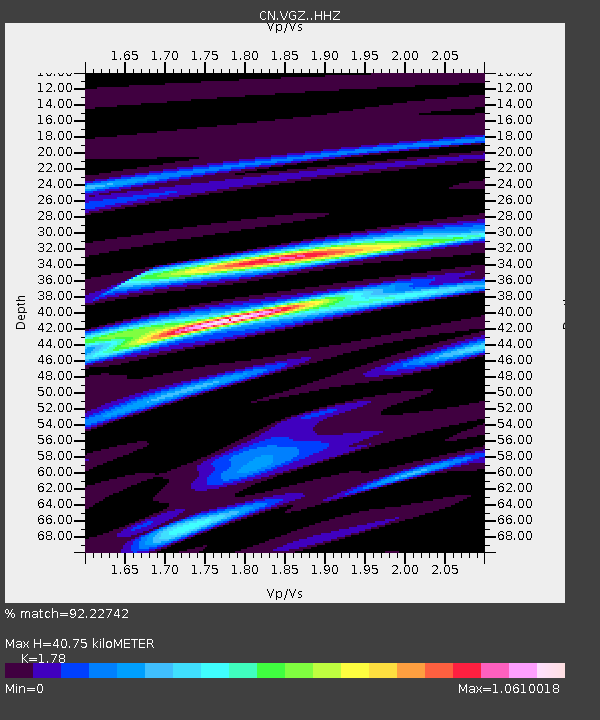
| Estimated Moho Depth: |
40.75 km |
| Estimated Crust Vp/Vs: |
1.78 |
| Assumed Crust Vp: |
6.566 km/s |
| Estimated Crust Vs: |
3.689 km/s |
| Estimated Crust Poisson's Ratio: |
0.27 |
|
| Radial Match: |
92.22742 % |
| Radial Bump: |
284 |
| Transverse Match: |
77.3823 % |
| Transverse Bump: |
400 |
| SOD ConfigId: |
29823551 |
| Insert Time: |
2022-12-18 20:02:36.433 +0000 |
| GWidth: |
2.5 |
| Max Bumps: |
400 |
| Tol: |
0.001 |
|

Signal To Noise
| Channel | StoN | STA | LTA |
| CN:VGZ: :HHZ:20221204T19:35:34.390015Z | 11.055188 | 3.7967816E-6 | 3.4343887E-7 |
| CN:VGZ: :HHN:20221204T19:35:34.390015Z | 4.672549 | 9.3778425E-7 | 2.0070081E-7 |
| CN:VGZ: :HHE:20221204T19:35:34.390015Z | 4.9441366 | 1.1078748E-6 | 2.2407852E-7 |
| Arrivals |
| Ps | 5.0 SECOND |
| PpPs | 17 SECOND |
| PsPs/PpSs | 22 SECOND |


